 June 8, 2020, was World Oceans Day, which aims to raise awareness in protecting and restoring our oceans and its resources. Earth observing satellites continuously watch over the ocean to monitor and protect our environment.
Covering more than 70 percent of Earth’s surface, the oceans are what makes this our “Blue Planet.” Our seas influence the climate, produce the oxygen we breathe, serve as a means of transport and a major source of food and resources.
But they are under stress from climate change, pollution and ocean acidification—all of which affect ecosystems and biodiversity. Satellite data increase our scientific understanding and support a range of environmental monitoring services in support of ocean conservation. From water saltiness to wave height, through sea level, sea ice and phytoplankton, satellites take stock of the ocean in many different ways.
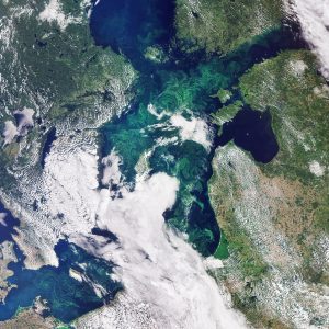
In this image captured by the Copernicus Sentinel-3 mission, the green algae blooms swirling around the Baltic Sea are visible. The Baltic Sea faces many serious challenges, including toxic pollutants, deep-water oxygen deficiencies and toxic blooms of cyanobacteria affecting the ecosystem, aquaculture and tourism.
Satellite data can track the growth and spread of harmful algae blooms in order to alert and mitigate against damaging impacts for tourism and fishing industries.
Image Credit: Contains modified Copernicus Sentinel data (2019), processed by ESA
