
By Mike Gundling
Ever since the first GPS satellite went aloft–and especially since the first smartphones and tablets provided GPS positioning–government, industry and academia have been in a never-ending search for new ways to use location-based data. Environmental organizations conduct wetland delineation surveys. Transportation companies track trucks and trains. Public-service officials seek law-enforcement and emergency preparedness solutions. Utilities seek efficiencies for maintaining power and pipeline infrastructure, and on it goes.
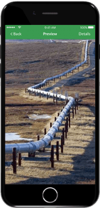
Energy companies and service providers such as Enmapp are customizing location-based apps with their vertical expertise to meet engineering standards and regulatory compliance requirements, helping accelerate pipeline construction and inspections.
The missions are different, and their operations span the globe, but a thread runs through solutions to the job and asset-management needs of all: location-based data collection, directed from a map, reported on a form and acted upon by headquarters and the field, in concert.
In many ways, TerraGo Technologies developed its zero-code, Platform-as-a-Service Magic application along a similar path to that of GPS users. As data customer needs expanded, TerraGo recognized a need to be industry-agnostic, and an opportunity to introduce and enhance collection vertically into every entity that uses geospatial data.
These days, that includes every organization–regardless of mission, product or management.
The opportunity for verticality also was fostered by a growing capability of a smartphone and tablet-savvy workforce that cut its location-based teeth on more than half the available apps for mobile devices–from restaurant finders to shopping guides to buying baseball tickets.
In developing a zero-code solution, TerraGo married an understanding that workers doing a job are likely to know more about that job than anybody else, with growing evidence that the demand from the field force for mobile apps to do the job better is outdistancing the capability of supplying those apps through coded development means, even those that involve altering off-the-shelf coded software. The bottleneck measures about 5 to 1, according to Gartner.
By and large, those workers are data collectors, not coders, so TerraGo developed Magic to be a click-not-code set of menus of field-proven attributes from which users can customize mobile apps by choosing workflows, accuracy needs, forms, photo and video support, business rules and IT-supplied security and enterprise controls. The six-month backlog to build an app with coded developers is reduced to hours and days by zero-code, and the field force works with tools they help develop.
Seiler Instrument customizes its Field-to-GIS app to meet the needs of clients in several industries, even those that need real-time centimeter-level accuracy with Bluetooth-connected Trimble GNSS receivers.
Partnerships with such firms as Trimble and LTI produce Bluetooth-enabled tools that measure with sub-meter or sub-centimeter accuracy. TerraGo recently partnered with Seiler Instrument to use Magic in building an advanced Global Navigation Satellite System (GNSS) collaboration platform.
“Our customers across different industries need a customizable mobile solution that delivers high-accuracy field data collection,” says Tom Rogers, Seiler’s Mapping Sales Manager. “With TerraGo Magic, we can build cloud-enabled apps without writing any code.”

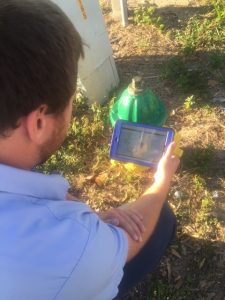
Versar’s field app is tailored specifically for environmental services work, such as stream assessments, for its federal, state, local and commercial clients.
Paper disappears when maps and aerial imagery–including from drones–are downloaded to mobile devices; when data, including video and photo support, are delivered digitally to headquarters, and when responses are sent back to the field through the same pipeline.
“We needed a solution that was customizable enough for the variety of client projects and flexible enough for field inspectors, engineers and other personnel,” adds Scott Riccardella, director of Strategic Business Development for Structural Integrity, a San Jose engineering firm that serves a worldwide clientele with solutions for evaluation and repair of hazardous oil and gas pipelines, as well as other energy related facilities.
Structural Integrity is a recent convert to zero-code.
“Because (Nondestructive Examination Determination) is tailored precisely to the project at hand, we needed an application that was easy to configure, not a hard-coded off-the-shelf product,” Riccardella adds.
Mark Kretz uses a custom app to collect data on water infrastructure assets for the City of Sebring, Fla. The city customized its app for water plant and wastewater operations, enabling them to share mobile forms and geo-referenced CAD drawings with field workers in real-time.
Besides the speed and flexibility of app creation, zero-code offers a rapid development system of updates, generally issued about six weeks apart, which respond to customer ideas and needs. For example, the latest release of Magic, which came out on Aug. 1, 2017, added laser-finder integration, offset data capture, Apple and Google turn-by-turn navigation, proximity alerts, and extended guidance for finding off-road assets and infrastructure. Customers like Seiler and Structural Integrity added these features with the click of a button.
As a Platform-as-a-Service feature, the frequent feature updates enable app users to keep their tools current, reducing the time and expense that are often part of an app lifecycle when it includes Python scripters or other complex app development systems to maintain. Zero-code users understand that every new job, and every task alteration, does not require reinvention of the wheel.
Organizations have often espoused getting the workforce involved in creating and performing tasks, and a zero-code platform like TerraGo Magic can help fulfill that quest for vertical involvement in ways never before seen. Government, industry and academia can use zero-code just as they did in learning to use GPS location-based data–and for the same reasons.
Mike Gundling is Vice President of Product Management and Marketing at TerraGo. Gundling has a proven track record for over 20 years in launching market-changing software products in enterprise, aviation and mobility sectors. For more information about TerraGo, please click here, and for more information about TerraGo Magic, please click here.


