
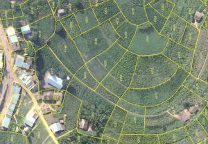
Pix4D drones and mapping software helped collect and create this cadastre image from Rwanda to improve land-management applications.
After Rwanda made waves in early 2016 for allegedly being the first country to approve drone delivery, people payed attention. The country, with its rolling hills and one of the fastest-growing economies in Central Africa, now has established regulations regarding drones and has become a vanguard of sorts for the region.
“My impression is that there is a huge market in Africa at the moment,” said Francesco Nex, assistant professor at the ITC Faculty, University of Twente. “They are growing very fast, with a shortage of surveying and maps available.”
Nex recently taught photogrammetry for an applied drone-mapping training event at INES-Ruhengeri Institute in Rwanda, along with his colleagues Rohan Bennett and Anton Vrieling. “They were very, very, enthusiastic,” Nex said of the 196 applicants, from which they selected 20 students from eight neighboring countries. “They really knew what they were looking for and had big expectations for this course and the use of drones.”
The training consisted of three parts: making orthophoto maps, 3D reconstructions and topography models from UAV images in Pix4Dmapper software; mapping applications in land administration; and mapping applications in food security.


