 The protection of nature environments aims to support sustainability. Thematic cartography plays an important role toward achieving this goal. Several surveying technologies are included for the production of this information and the geo-referencing of cultural sites.
These include Global Navigation Satellite Systems (GNSS) technologies, remote aerial recognition and analysis and wireless applications. The technological developments emerging from Italian legislative changes related to the new discipline of aerial surveying have deeply modified the instruments and the methodologies for the analysis of regional territories.

This has helped to develop new instruments and applications for the documentation and the survey of the cultural sources and the cultural landscape. The project aims to built various degrees of analysis in order to protect and valorise the cultural heritage with the support of novel Educational & Research Programmes within Italy. This research also represents an important starting point for the implementation of new tested analysis and updating under the programmes.
Issues related to common educaton approaches
Yet with all the benefits of cyberspace, distance students and researchers aren’t able to meet face-to-face with professors and classmates, which might cause some concern for those considering distance education. Although much attention is given to novel combination of face-to-face and online innovations in education, we observe that the majority of institutions aren’t set up yet to offer innovative learning solutions.
In particular, users in the field of nature protection and sustainability have a wide range of requirements. Member States are at different stages of implementing European Directives and applying national monitoring systems for a diverse range of purposes. The diverse range of habitat conditions within a single country, and between countries in different parts of Europe and worldwide, together with site specificities, make a single catalogue of products not flexible enough to support users in their mapping and monitoring activities.
Another important factor is that cloud cover problems and satellite availability mean that a mix of instruments must be used, combined with ongoing airborne campaigns. Some users’ current interest is in learning what can be done, to have guidelines for data and analysis concepts, to support developing strategies and where the operational balance between field work, airborne and satellite methods may not yet be clear. The service emphasis therefore becomes advisory and focused on the provision of guidelines for ‘best practice’, supported by an ongoing R&D agenda.
Developing infrastructure products
In theory, the audience who will benefit most from blue infrastructure products are managers within European governments.
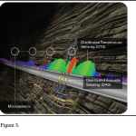
For example, the conventional measurement of water quality requires in situ sampling and expensive and time-consuming laboratory work. For this reason we tried to develop low-cost morphological monitoring techniques based on traditional surveying equipment (such as theodolites, electronic distance measuring devices, both absolute at sub-millimetric accuracy).
 We have also attempted to develop novel 2D/3D thematic cartography and remote sensing analysis technques with the support of European SMEs and Research Centres under European Programmes for Cultural and Natural Heritage Management (since 1993).
These techniques were supplemented by satellite positioning technology based on different technologies. The early GPS deformation monitoring techniques combined with remote sensing analysis were developed for the benefit of urban planners, who were involved in the conservation and valorization of cultural and landscape heritage in England, Sicily and other European test sites (such as Lombardia, Friuli Venezia Giulia, Abruzzo, Marche and Wahlkreis in Switzerland).
Furthermore, other projects are employing new methodologies, concepts and demonstration products developed to address requirements that arise from other European policies and initiatives (e.g. the CAP reform, SEBI 2010), as well as habitat mapping and monitoring activities outside of the NATURA 2000 network.
Use of GNSS for heritage studies
The initial projects involving GPS several years ago suffered from a number of limitations which affected the coverage, accuracy and reliability of the satellite measurements. “The GNSS allow continuous nearly-real-time monitoring of the small movements of points”. But new systems (evolved over the years from strict military use) can control commercial mainstream application for several security reasons.
We have developed pilot experiments on the field of novel applications (Virtual Reference Station, GPS, wireless-applications, web services, etc.) in order to demonstrate that geomatics are useful to monitor construction yards and natural heritage. It is expacted that the development of Galileo and its proposed interoperability with GPS along with EGNOS will contribute substantially to the quantity and quality of the satellite measurements thereby improving the quality of the deformation monitoring processes.
The availability of signals from two different satellite systems is likely to reduce the price of GNSS receivers and sensors and thus enabling a wider spatial coverage with an increase in the number of monitoring points. In particular Galileo will increase the integrity of the GNSS measurements, which is very important for such applications affecting Safety of Life (SoL), and therefore involving legal and economic consequences.
In this context GALILEO will open a new era in navigation.. Furthermore, scientists working to validate data from the European Space Agency (ESA) Soil Monitoring and Oil Salinity Sensor (SMOS) will get help but will require further validation. The method used in this paper made correlations using simultaneous collected remote data, field VRS data, and field collected water quality data to demonstrate the feasibility of remote sensing techniques for water quality monitoring in large rivers.
Value of remote sensing to field researchers
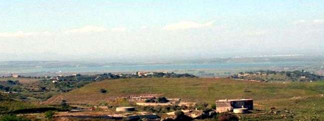
Other sources such as aerial photography and ortophotos has revealed the wealth of historical greenways that is one of the fundamental resources for our understanding the connection between cultural landscape through time (diachronic variations). Some tests has been carried out during the XIV Summer School “Digital Arial Photography and GIS based interpretation” 2005, Siena and Grosseto University, in collaboration with LAP&T, British Cultural Heritage and AARG (Arial Archaeology Research Group) under the Cultura 2000 Programme.
The approaches passively recorded reflected visible and non-visible solar radiation in specific spectral bands (such as the NIR band) and are able to show vegetation stress, soil moisture variation etc. through which greenways were identified. Those information gives also the opportunity to offer a method of classification of new green infrastructure in order to link areas with peculiar environmental characteristic (such as “Siti di Interesse Comunitario” (SIC) and “Zone di Protezione Speciale” (ZPS) and cultural landscape in general.
Summary
This study attempted to provide a basic hypothesis of landscape planning on the evidence of hedgerows and riparian linear green patterns, however these efforts must be followed by further field work and surveying. This work leads to further use of remote sensing and air photography related to the improvement of the techniques of surface recognition and in situ analysis (e.g. spettroscopy, ICT and batimetry).
Acknowledgement
The author wishes to acknowledge with gratitude all her students.
—————————————————————————
Article by Prof. Arch. Agata Lo Tauro, Minister of Education, the University and Research, IPSIA “Majorana-Sabin”, Viale Libertà 151, 95014, Giarre, Italy. e.mail: agatalotauro at tiscali.it http://www.miur.it
Further reading
Carrillo, M. and Kuhns, L. Data to Design: Good Design Requires Accurate Base Maps. Cadalyst, Integrating Technology for Manufacturing, AEC and GIS, Jan 7, 2009, www.cadalyst.com
Lo Tauro, A. (2009). Georeferencing of Cultural Heritage and Risk Chart: research of novel applications EVA 2009 Florence Proceedings, 151-156
Lo Tauro, A 2009. Telerilevamento e cartografie tematiche per il riordino del sistema di sicurezza territoriale e difesa del suolo – in Atti della XIII Conferenza ASITA, pp. 1297- 1302 (1-4 dicembre 2009, Bari, pen-drive)
Lo Tauro. A. (2009): Archaeological and landscape investigation: Aerophotos anh Hyperspectral Analysis for Thematic Cartography. In: Science and Technology for Cultural Heritage, pp. 66-72
Lo Tauro. A. (in press): Data integration e GIS per analisi di Greenways (in Italian), In: Science and Technology for Cultural Heritage, n. 19, 2010
Volker, L. (2008). The 2008 edition of the CEOS Earth Observation Handbook, European Space Agency, CEOS.
Zhang, Y. (1999). Optimization of Building Detection in Satellite Imagery by Combining Multispectral Classification and Texture Filtering. ISPRS J Photogramm, 54, 50-60.
Zipf, A. 2008. Open Standards, Free Geodata and 3D, GIM International, pp. 67
Web sites:
Italian Presidential Decree 2000
(Presidential decree, 29 September 2000, n. 367 and s.m.i)
http://www.asita.it
http://www.cgtsrl.it
http://www.corp.at
http://cipa.icomos.org
http://www.esa.int/
http://cordis.europa.eu/fp7/home_en.html
http://www.european-waternews.com
http://www.flirthermography.com
http://www.icomos.org/
http://www.icomos.org/
http://www.mit.gov.it
http://www.miur.it
http://www.noaa.gov/
http://www.umuc.edu
http://www.unavco.org
http://whc.unesco.org/