Tuesday, May 17th, 2011
Effective spatial data management is essential to government administration at all levels from local to national. The City of Springfield and NASA Ames Research Center have begun collaboration on the technology and framework needed for sustainable spatial data management across all levels of government. This technology is open source and purposed to enhance the sharing
Wednesday, April 6th, 2011
Recently, a national CORS network, called CORS-TR network has been established by Istanbul Kultur University in Turkey and Northern Cyprus. The project was sponsored by the Scientific and Technological Research Council of Turkey (TUBITAK). The network was designed to fulfill several important tasks ranging from geodetic measurements, crustal deformation studies to modeling the atmosphere (troposphere

Sunday, March 20th, 2011
One of the biggest issues or discussion subject within the whole geographic information domain at the moment is the ever-changing demands for handling information in a better and more efficient way. The domain is expanding in all kinds of directions. What remains is geo-referenced information handled with a computer. We are seeing applications and demonstrators
Monday, February 21st, 2011
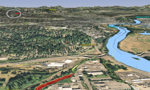
Cicada Design Inc. recently won a 3D Award for Territory Management at the imagina conference in Monaco in the Urbanism and Landscape section. Their work for the Mount Pleasant Secondary Plan located near Toronto, Canada included restoration of a natural heritage system for the area including woodlands, wetlands, watercourses and valleys. This effort included a high

Saturday, February 5th, 2011
Over the past decade, green building has gone from the fringe to the mainstream of the building industry. In many communities, buildings have “gone green” by adopting strategies such as integrative design, energy modeling, commissioning, enhanced energy efficiency, renewable materials, attention to daylight and views, water conservation measures, and on-site renewable energy generation. Use of
Monday, October 11th, 2010
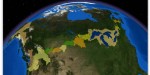
It is a truism that Canada and the United States share the longest undefended border in the world. What is often overlooked in the observation, though, is that much of the border is water. More than 300 lakes and innumerable streams and rivers are part of or cross the international boundary, accounting for 40 percent
Sunday, June 8th, 2008
How do we retrace our ecological footprints? Where will the footprints lead? Scientists at the Woods Hole Research Center (WHRC) are tracking carbon footprints across the globe starting with U.S. forests. One ongoing study, using geographic information system (GIS) technology, is measuring the carbon-rich biomass in heavily wooded areas to indicate the effect that deforestation and
Sunday, June 1st, 2008
While we know and understand that the Earth’s climate undergoes natural cycles of glacial and inter-glacial events, there is widely accepted and mounting evidence to suggest that we are accelerating this natural phenomenon and that the changes in global climate are largely due to the amount of greenhouse gases (GHG) in the atmosphere. Human activities,
Sunday, May 18th, 2008
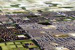
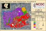
Soon, if it has not already happened, the majority of the human species will live in sprawling cities. As urban density moves forward, the need to understand the dynamics of a particular urban region, the interrelationships between population, land use, transportation, economics, environment, and other factors is crucial to effectively develop policies and determine where
Sunday, May 11th, 2008
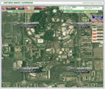
You do not have to be in the geospatial industry to be amazed at images of recognizable locations. Everyone is curious to see a satellite image of his or her home or other areas of interest. In addition, an increasing number of organizations are also realizing the value of imagery, when combined with other geospatial
