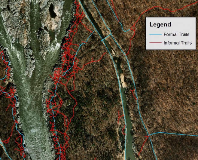
USGS research documented these informal trails created by off-trail visitor traffic in areas with large numbers of rare and endangered plants in Potomac Gorge near Washington, D.C. (Credit: Jeffrey Marion, USGS)
Most visitors to protected natural areas hike on trails created with hardened treads designed to sustain traffic. However, heavy hiking traffic and use by mountain bikers, motorized vehicles and horseback riders all take their toll. Parks also are becoming more crowded, with long lines of trail users during the popular summer season. More visitors have been venturing off trails, trampling and removing protective vegetation and organic materials. This can compact soils and increase water runoff and erosion. Soil loss is the most significant and long-lasting environmental impact.
To address this issue, USGS scientists are collaborating with university social scientists to investigate sustainable trail design guidance and actions to deter off-trail hiking. As an example, a study was conducted to protect large numbers of rare plants near the Billy Goat Trail in Washington, D.C. In the study, scientists tested various communication methods at formal trailheads and at informal trails created by visitors—including “don’t walk here” signs and placement of organic materials, such as leaves—to hide and discourage use of the informal trails.
Another study area was Cadillac Mountain at Acadia National Park in Maine, where visitors have trampled fragile subalpine soils and vegetation on the summit. The USGS provided the science in support of a collaborative effort to develop best-management practices with recommendations that included educational signs and low fencing along trail borders. Research findings identified the most-effective educational messages and suggested that the formal trail be extended and widened, with short side-trails to the most scenic spots.


