 In this article we look at the e-mobility initiative BALLADE and show how the success of such efforts will depend on many different Standards Development Organizations (SDOs) working together to “tune” the Smart Grid for efficient communication of location information.
BALLADE
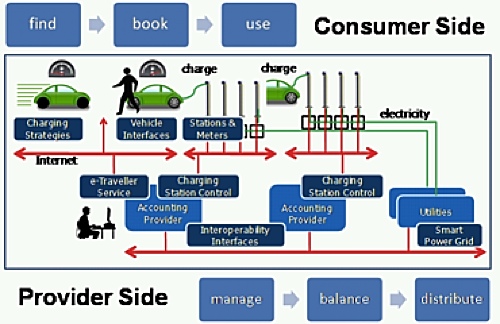
The e-mobility initiative BALLADE (named in German “Benutzerfreundliche allgegenwärtige Ladestellen für Elektrofahrzeuge), is a European experiment in managing networks of intelligent geo-located charging stations for Plug-in Electric Vehicles (PEVs). In this trial program, drivers of e-vehicles typically discover the charging stations through navigation services delivered by the Internet-connected navigation devices in their vehicles.
BALLADE ecosystems of electromobility.
To maximize opportunities for commercial players and others to build on the results of BALLADE, the charging stations have been made discoverable and queryable through existing international standards for open interfaces and encodings. BALLADE uses the OGC Web Feature Service (WFS) Interface Standard. The use of OGC standards in this application derives from investigations by EOX and others of the suitability of OGC Web Service (OWS) and OGC Sensor Web Enablement (SWE) standards for management of smart meter networks.
Various charging and online parking time booking mechanisms at user-selected stations are being tried in BALLADE. User authentication and authorization is enabled. To support the capabilities of the Smart Grid, power levels at charging station outlets are dynamically controllable by operators for implementing load-balancing and load-shifting policies. The stations also provide smart energy metering for monitoring and user accounting.
The BALLADE Geospatial Infrastructure subsystem implements an “e-Mobility Application Profile” of WFS and its transactional variant WFS-T for the charging station real-time user information service. The WFS “GetCapabilities” operation is invoked via a URL:
http://thebe.eox.at/wfs?service=WFS&;request=getcapabilities
The “http://thebe.eox.at/wfs?service=WFS&;request=getfeature&typename=ballade2:chargepoint_feature” URL points to a WFS Interface whose Point of Interest (POI) features communicate, among other attributes, status information such as whether the charging stations are free, occupied, reserved or out-of-order. An OpenStreetMap-based service interface that implements the OGC Web Map Service (WMS) Interface Standard and a gazetteer function help end-users users and operators of the BALLASE B2B Service Platform see the status of charging stations within a region. Integrations with regional and super-regional Intelligent Transportation Systems in Europe such as the “in-time” system, the “e-Mobility Model Region Vienna”, and automotive OEMs are on-going within the BALLADE initiative.
The BALLADE participants are also looking at the OGC SWE framework and its suitability for the management of smart meter networks. Other activities are addressing charging station information distribution, or propagation, in multi-provider federations and user roaming use cases.
OGC/CEN/TC 287 Smart Grid Workshop
The Open Geospatial Consortium (OGC) and European Committee for Standardisation CEN/TC 287 held an OGC Smart Grid and SDI workshop at JRC’s EnviroInfo conference 5-7 October 2011. The workshop was sponsored by Sparx Systems, an OGC member providing a Unified Modeling Language (UML) modeling environment used for architecting and designing distributed, Web service based information systems such as those involved in e-mobility and the Smart Grid. UML models are indispensible in standards efforts involving multiple standards organizations. Gerhard Triebnig of EOX gave a presentation on the BALLADE project.
Efficient communication of location is obviously important in e-mobility applications, which sometimes involve electric power grids, but location is also critical in managing the flow of electricity between non-mobile devices. Every Smart Grid component — transformer, meter, air conditioner, power plant, electric car, solar panel, etc. — has a location on Earth. Every grid event or phenomenon — brown-out, demand variability, power surge, regulation, transmission loss, etc. — occurs within some time interval and at some location in space along the grid’s physical network. The same is true for every external event or phenomenon that affects the grid, such as weather alert or cyber-attack. Spatial parameters have significant impact in every scenario affecting the grid.
The Smart Grid has been a topic for OGC membership discussion and staff outreach since 2009, and there is growing interest among the OGC membership. At the Internet of Things Workshop held at the OGC Technical Committee meeting in Brussels in November 2011 the “e-Mobility Application Profile for WFS” was proposed by Daniel Santillan for further consideration by standardization groups. Eric Nelson recently brought Synaptitude Consulting into the OGC specifically to advance open location standards for the Smart Grid. He worked with others to organize a two-hour Smart Grid ad hoc meeting (Tuesday, March 20, 8-10 am) at the upcoming OGC Technical Committee meeting in Austin. The meeting is open to the public. Member attendees will discuss next steps, which may include drafting a charter for an OGC Smart Grid Domain Working Group.
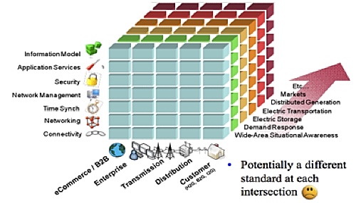
Many standards and many standards organisations are involved in the Smart Grid. (Figure from the US National Institute for Standards and Technology – NIST.)
Many standards development organizations (SDOs) are involved in the Smart Grid standards effort worldwide. At the CEN/TC 287 / OGC Smart Grid meeting, Margaret Goodrich of Systems Integration Specialists Company, Inc. (SISCO) will present the International Electrotechnical Commission’s (IEC) plans for Weather Exchange Model (WXXM) harmonization and also plans for incorporating the OGC GML standard into the IEC’s Common Information Model (electricity) (CIM) standards.
OGC sessions are frequently attended by interested members of other SDOs, because location, indoor and outdoor, is a peripheral but important issue in many other standards efforts. Cross-SDO collaboration is essential to avoid situations in which SDOs are inadvertently creating interoperability-preventing “stovepipes.” Margaret Goodrich connects multiple SDOs. She was the Test Director for all CIM-GID (Generic Interface Definition) Interoperability (IOP) Tests on behalf of EPRI (Electric Power Research Institute, a key US Smart Grid standards player). She serves on the IEC WG19, WG16, WG21 and WG14 standards working groups supporting the CIM standards. Margaret is also on the Board of Directors of the UCA International Users Group (UICIug), is active in the CIM Users Group, is co-chair of the UCA International Users Group interoperability testing activities and participates in several other of the working groups in those organizations. She is the Vice-Chair of the Institute of Electrical and Electronics Engineers Power and Energy Society (IEEE-PES) CIM Task Force.
The Indoor/Outdoor Location Connection
3D spatial information, outdoors and indoors, is an important consideration in the Smart Grid and even in e-mobility. Consider, for example, the need for a standard encoding system for charging station location in a multi-level parking garage, or the need for Intelligent Transportation Systems to utilize engineering design information about tunnels and sub-surface road drainage systems. Transportation issues and flooding were among the concerns that motivated the Netherlands’ 3D Pilot NL, which led to the establishment of a national 3D standard based on an international standard, the OGC City Geography Markup Language (CityGML) Encoding Standard.
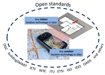
Many standards and many standards organisations are involved in efforts to connect indoor and outdoor location information systems.
Several years ago, the buildingSMART alliance, the OGC (OGC) and various Architecture, Engineering, Construction, Owner and Operator (AECOO) sponsors participated in the OGC AECOO-Phase 1 Testbed. The testbed explored business transformation as defined in the United States National Building Information Modeling Standard, Part 1 (NBIMS), employing technology for interoperability involving intelligent building models with 3D geometric capabilities. Business and communications, quantity take-off for cost estimating, and energy analysis were considered as they relate to planning and design for a capital facility.
The recent OGC 3D Portrayal Interoperability Experiment addressed communication between systems using various digital landscape models, city models, and interior models, including the OGC CityGML encoding standard. The OGC 3D Information Management Domain Working Group (3DIM) will meet in Austin this month, where members are also holding the first official meeting of an OGC Standards Working Group to advance IndoorGML (http://www.opengeospatial.org/pressroom/pressreleases/1537). IndoorGML is a specification that has been developed subsequent to a 2009 special OGC meeting on indoor location (http://www.ogcnetwork.net/node/624).
Several OGC Working Groups have a 3D interest, including 3DIM, IndoorGML, CityGML and the Augmented Reality Markup Language (ARML) Standards Working Groups. They will meet together in Austin to discuss how to work together.
Conclusion
Open spatial standards are necessary to enable the flow of location information in a wide variety of applications, as becomes evident for example in the BALLADE example. Such standards are increasingly important in an era when location information is being produced and used at an exponentially increasing rate by an exponentially increasing number of devices. Standards stimulate market development, reduce user frustration and accelerate the rollout of technologies that address critical societal needs for safety, security, cost savings and sustainable use of resources. Because location is cross-cutting issue that in some way touches the work of most information technology standards organizations, it is critical that the OGC works with those organizations to build a common global location standards framework. This only happens if location information stakeholders participate actively in standards work.