
Monday, December 18th, 2017
Along with the larger forces of climate change, another contributing factor to the fierce wildfires in California has been the dry soil conditions. Light rainfall, combined with heavy use of aquifers by large farms, has created perfect conditions for an inferno. Stories of homeowners saving their homes by turning on sprinklers remotely are not as
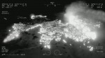
Tuesday, October 17th, 2017
In support of CAL FIRE’s firefighting efforts in Northern California, the California Air National Guard’s 163d Attack Wing operating out of March Air Reserve Base is using MQ-9 Unmanned Aircraft Systems (UASs) with full-motion video (optical and infrared) and ground imaging Synthetic Aperture Radar (SAR) capability, which can see through clouds and smoke. “The 163d
