Monday, September 11th, 2017
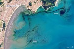
In early September 2017, ocean scientists noticed something swirling in the waters off the coast of the Brazilian state of São Paulo. The sinuous threads of darkness amid the blue Atlantic Ocean were not caused by oil; they were the result of a phytoplankton bloom. The dark colors are probably high concentrations of dinoflagellates, according
Tuesday, March 7th, 2017
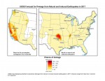
New U.S. Geological Survey (USGS) maps identify potential ground-shaking hazards in 2017 from human-induced and natural earthquakes in the central and eastern United States (CEUS). This is the second consecutive year both types of hazards are forecasted, as previous USGS maps only identified hazards from natural earthquakes. This research recently was published in Seismological Research
Tuesday, February 14th, 2017
A new JavaScript library, called GWIS (Graphing Water Information System), can create time-series plots of information measured at U.S. Geological Survey hydrologic data collection sites across the United States. Developed by the USGS Texas Water Science Center, the user-friendly interface integrates the open-source dygraphs JavaScript charting library with hydrologic data provided by USGS water services. Using GWIS, one or more interactive plots
Tuesday, January 17th, 2017
An annual award for outstanding achievement in remote sensing A longtime innovator in space-based Earth observation at Boston University and a team that has paved the way for the next generation of satellite precipitation observations have both been honored with the 2016 William T. Pecora Award for achievement in Earth remote sensing. Sponsored by the
Tuesday, January 3rd, 2017
Reston, VA – MAPPS (www.mapps.org), the national association of private sector geospatial firms, today announced the release of model legislation for state legislaturesto help coordinate state level partnerships for the collection of enhanced elevation data in support of the nationwide effort led by the U.S. Geological Survey (USGS) in its 3D Elevation Program (3DEP). MAPPS
Tuesday, December 27th, 2016
The entire population of southwestern Idaho’s Gem County depends on aquifers for its drinking water. The water in those aquifers is of generally good quality according to a U.S. Geological Survey report released today. The study was prompted by concerns that rapidly growing population and changes in land use, including potential natural gas exploration and
Tuesday, December 13th, 2016
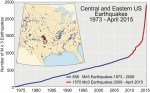
The central United States has undergone a dramatic increase in seismicity during the last six years. From 1973-2008, there was an average of 24 earthquakes of magnitude 3 and larger per year. From 2009-2014, the rate steadily increased, averaging 193 per year and peaking in 2014 with 688 earthquakes. So far in 2015, there have
Tuesday, November 22nd, 2016
The Open Geospatial Consortium (OGC®) is inviting members and the public to attend the OGC Testbed 12 demonstration and exposition of the technology developed during its latest Interoperability Program initiative on 29 November 2016 at the USGS in Reston, Virginia. The Testbed 12 sponsors – DigitalGlobe, Inc., European Organisation for the Safety of Air Navigation
Tuesday, November 15th, 2016
COLORADO SPRINGS, Colo.– The Sanborn Map Company, Inc. (Sanborn) has won a Geospatial Products and Services Contracts (GPSC) award from the U.S. Geological Survey (USGS) that allows the agency to negotiate task orders with Sanborn during the next five years. The indefinite delivery/indefinite quantity (IDIQ) contract is one of a suite of multi-award agreements with a
Wednesday, November 9th, 2016
For the first time, the United States will host the international Volcano Observatory Best Practices workshop, previously held only in Italy. The workshop will take place this month in Vancouver, Washington. It is designed specifically for volcano observatories around the world and their staff to exchange ideas and best practices with each other. “In order
