Monday, September 11th, 2017
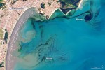
In early September 2017, ocean scientists noticed something swirling in the waters off the coast of the Brazilian state of São Paulo. The sinuous threads of darkness amid the blue Atlantic Ocean were not caused by oil; they were the result of a phytoplankton bloom. The dark colors are probably high concentrations of dinoflagellates, according
Wednesday, February 1st, 2017
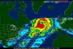
More accurate, immediate and economical information on severe weather phenomena such as hurricanes soon could be available thanks to the Weather Hazard Alert and Awareness Technology Radiation Radiosonde (WHAATRR) Glider. According to project manager Scott Wiley, the vehicle could potentially save the National Weather Service up to $15 million a year compared to current methods.
Tuesday, January 24th, 2017
MELBOURNE, Fla. – The National Oceanic and Atmospheric Administration (NOAA) has released the first image taken by Harris Corporation’s (NYSE:HRS) Advanced Baseline Imager (ABI) onboard their next-generation weather satellite. The image taken from the Geostationary Operational Environmental Satellite-16 (GOES-16) is of Earth’s full western hemisphere with detailed cloud and water features. The Harris ABI, the
Tuesday, November 29th, 2016
On Sept. 21, 2014, NASA scientists and engineers launched RapidScat toward the orbiting International Space Station, 250 miles above Earth’s surface, with a few objectives in mind: improve weather forecasting on Earth, provide cross-calibration for all international satellites that monitor ocean winds, and improve estimates of how ocean winds change throughout the day. Following the
Tuesday, October 25th, 2016
NOAA Research today announced $6 million in funding to get scientific and technological advances from the government and academia to NOAA’s National Weather Service (NWS) more rapidly, improving severe weather and water hazards forecasting. “NOAA has sharpened its focus on speeding up this important transition of technology to National Weather Service day-to-day operations,” said John
Wednesday, September 28th, 2016
REDLANDS, Calif. — Esri, the world leader in geographic information system (GIS) technology, today announced its participation in the Weather-Ready Nation Ambassador initiative. Recognized by the National Oceanic and Atmospheric Administration (NOAA) to protect US citizens and fortify infrastructure against the threat of extreme weather, the Weather-Ready Nation (WRN) Ambassador initiative collaborates with organizations that
Wednesday, September 14th, 2016
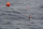
Using a new system of drifting buoys, scientists from NOAA’s Southwest Fisheries Science Center in La Jolla, Calif., will have a much better chance of hearing beaked whales in their deep-water habitat off the West Coast. About 20 buoys will be deployed from a NOAA ship with a listening device suspended 330 feet below the
Friday, September 9th, 2016
NORCROSS, GA – Quantum Spatial, Inc., the nation’s largest independent geospatial data firm, announced today that the company will be acquiring, processing and delivering high-resolution aerial LiDAR data and multispectral imagery data from an unmanned aerial system (UAS) for the National Oceanic and Atmospheric Administration (NOAA) Office for Coastal Management (OCM). The project will focus
Wednesday, September 7th, 2016
PASADENA, Calif. — Tetra Tech, Inc. (NASDAQ: TTEK) announced today that the National Oceanic and Atmospheric Administration (NOAA) has awarded the Company a $49 million, indefinite delivery, indefinite quantity contract to support the Office for Coastal Management’s (OCM) Digital Coast program. Tetra Tech is one of five contractors who will share in the contract ceiling
Thursday, August 25th, 2016
New Real-Time Maps Transform Forecast Data into Vivid Pictures of U.S. River Flows REDLANDS, Calif.—August 25, 2016—Smart-mapping leader Esri today released a beautiful, robust new collection of Web maps that forecast NOAA stream-flow data throughout the continental U.S. Esri’s multiscale visualization of the National Water Model enables forecast water flows in real time at high
