Tuesday, January 24th, 2017
Hydrologists at the Colorado Basin River Forecast Center are providing streamflow forecasts for watersheds within the Colorado River Basin, which includes some of the most parched land in the United States. “The forecasts we get from the center provide crucial information for managing our water resources and reservoir facilities,” said Dave Kanzer, a deputy chief
Tuesday, January 24th, 2017
Bremen, 24/01/2017 – Mid-January 2017 Airbus Defence and Space delivered to NASA a propulsion test module for the Orion programme. The Propulsion Qualification Test Model (PQM) will be used to check that the Orion European Service Module (ESM) spacecraft’s propulsion subsystem functions correctly. On behalf of the European Space Agency, Airbus Defence and Space is
Tuesday, January 17th, 2017
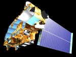
An annual award for outstanding achievement in remote sensing A longtime innovator in space-based Earth observation at Boston University and a team that has paved the way for the next generation of satellite precipitation observations have both been honored with the 2016 William T. Pecora Award for achievement in Earth remote sensing. Sponsored by the
Thursday, January 5th, 2017
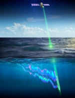
A new study using a NASA satellite instrument orbiting Earth found that small, environmental changes in polar food webs significantly influence the boom-and-bust cycles of phytoplankton. These findings, recently published in Nature Geoscience, will supply important data for ecosystem management, commercial fisheries and understanding of the interactions among Earth’s climate and key ocean ecosystems. “It’s
Tuesday, November 29th, 2016
On Sept. 21, 2014, NASA scientists and engineers launched RapidScat toward the orbiting International Space Station, 250 miles above Earth’s surface, with a few objectives in mind: improve weather forecasting on Earth, provide cross-calibration for all international satellites that monitor ocean winds, and improve estimates of how ocean winds change throughout the day. Following the
Friday, November 11th, 2016
VIENNA, Va. – AT&T* and the National Aeronautics and Space Administration (NASA) are researching traffic management solutions for Unmanned Aircraft Systems (UAS). The goal is an Unmanned Aircraft System Traffic Management (UTM) solution that supports the safe and highly secure operation of drones in the national airspace. AT&T has been working with NASA and other companies
Tuesday, November 8th, 2016
Scientists at NASA’s Jet Propulsion Laboratory (JPL) in Pasadena, Calif., have been working on the tricky problem of CubeSat transmission antennas, which must be small enough for these diminutive devices yet still transmit data through the huge expanses of space. “It’s like pulling a rabbit out of a hat,” said Nacer Chahat, a specialist in
Wednesday, October 26th, 2016
The National Aeronautics and Space Administration (NASA), the European Space Agency (ESA) and Qascom, an Italian company specializing in Galileo, are collaborating to build the first GPS and Galileo receiver to be tested on board the International Space Station (ISS) Space Communications and Navigation (SCaN) Testbed. SCaN is a payload developed by NASA that has
Monday, October 24th, 2016
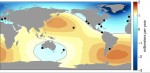
A new study using NASA satellite data finds that tide gauges—the longest and highest-quality records of historical ocean water levels—may have underestimated the amount of global average sea-level rise that occurred during the 20th century. A research team led by Philip Thompson, associate director of the University of Hawaii Sea Level Center in the School
Tuesday, October 11th, 2016
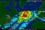
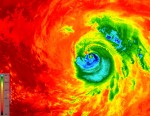
As Hurricane Matthew developed into a Category 4 hurricane that pummeled the Caribbean and southeastern United States, killing more than 1,000 people, disrupting electricity and other utilities to hundreds of thousands, and causing billions of dollars in economic damage, many of the world’s satellites and sensors were tuned to the storm, and recorded its path
