Monday, November 6th, 2017
Members of the California Citizen’s Redistricting Commission went to Washington, D.C. in July 2017 to accept the Roy and Lila Ash Innovations Award for Public Engagement in Government for its California Redistricting Panel, which used Caliper’s Maptitude for Redistricting to draw its 2012 Congressional and State Legislative boundaries that have been recognized for effectively eliminating
Friday, July 14th, 2017
NEWTON, MASSACHUSETTS (USA) – The National Conference of State Legislatures (NCSL) Annual Conference will be held August 6-9, 2017 in Boston, Massachusetts (USA). NCSL is the only national organization to represent state legislatures in the United States and the conference allows attendees the opportunity to learn more about what other state leaders are faced with
Wednesday, July 5th, 2017
NEWTON MA (USA) – Address data in New Zealand continues to boost the economy because of shrewd moves by the New Zealand government. Initiatives under the Business Growth Agenda and the Open Government Partnership are making public data more available for the benefit of everyone in New Zealand. With precedent in only a few countries such as Denmark and Australia, these “open data”
Friday, March 3rd, 2017
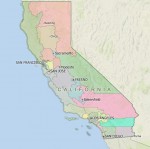
NEWTON, MASSACHUSETTS (USA) – Caliper is pleased to announce that the State Legislative Districts Data Product is now available for the entire USA or for a single US state. Three area databases are provided that reflect the latest boundaries for Congressional Districts, State House/Assembly (lower chamber) districts, and State Senate (upper chamber) districts. These layers
Friday, March 3rd, 2017
NEWTON, MASSACHUSETTS (USA) – Maptitude 2017 dominates the space vacated by MapPoint®, supporting Microsoft MapPoint-like tools & queries. With enhanced versions of the features that MapPoint users are familiar with, Maptitude retains the ease-of-use of the MapPoint tools while providing functionality that MapPoint users could only wish for. The new and improved tools include: Route/directions
Thursday, June 23rd, 2016
NEWTON MA (USA) – Address data has been set free in Australia because of a shrewd move by the Australian government. Initiatives under the National Innovation and Science Agenda are making public data more available for the benefit of everyone in Australia. With precedent in only a few countries such as Denmark, such “open data”
Friday, June 10th, 2016
NEWTON MA (USA) – Recent news coverage highlights the value that Maptitude brings to organizations. Maptitude mapping software has been featured in Directions Magazine as part of their Geospatial on a Budget series. Due to popular demand, Maptitude has a dedicated installment that features real user feedback and emphasizes the robustness of the software. In the words
Monday, February 8th, 2016
NEWTON, MA (USA) — Caliper Corporation, the leader in the development of cost-effective professional map software, has announced that is has become an associate member of the Open Geospatial Consortium. As an Associate Member, Caliper will participate in OGC’s Technical Committee Discussion, contributing to the professional discussion of issues and items related to the specifications that
Thursday, December 3rd, 2015
Maptitude is a robust and easy-to-use professional mapping application that can be used within almost any industry. Caliper Corporation, founded in 1983, first released Maptitude in 1995 and the product has benefitted from two decades of user focused development to ensure that the software meets our customers’ needs.
Tuesday, March 24th, 2015
NEWTON, MASSACHUSETTS, March 24, 2015 — Caliper is excited to announce that 114th Congressional Districts data are now available for the entire USA. These are the most accurate boundaries available, reflecting our expertise in the field as the market leading redistricting software package.
