Wednesday, October 4th, 2017
Ever wondered what the name of that hill is in the distance? Or how far away a town is from the spot you are standing in? Well, all you need is a mobile phone or tablet and Ordnance Survey’s new augmented reality feature will do the rest! The hugely popular OS Maps application, now includes a
Tuesday, March 7th, 2017
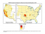
New U.S. Geological Survey (USGS) maps identify potential ground-shaking hazards in 2017 from human-induced and natural earthquakes in the central and eastern United States (CEUS). This is the second consecutive year both types of hazards are forecasted, as previous USGS maps only identified hazards from natural earthquakes. This research recently was published in Seismological Research
Tuesday, June 21st, 2016
Today Ordnance Survey (OS) is mining data used daily at all levels of national and local government, by the emergency services and large and small businesses. That data is also set to provide the foundation on which Great Britain will build its Smart future. Yet to celebrate its 225th anniversary, OS has returned to its roots and
Tuesday, May 17th, 2016
Leicestershire, UK, 17 May 2016 – Aerial mapping company Bluesky is completing an extensive update of the National Tree Map which uniquely identifies the location, height and canopy cover of more than 280 million trees nationwide. The update, which covers more than 40,000 square kilometres – an area equivalent to twice the size of Wales,
Thursday, March 10th, 2016
Leicestershire, 10 March 2016 — High resolution aerial photography and 3D terrain maps created from airborne laser surveys are being used to design new golf courses. Creative Golf Design, an award winning firm of golf course architects, regularly downloads the highly detailed images from Bluesky’s online MapShop to provide a map-accurate base onto which course design
Friday, September 7th, 2012
More government agencies and nongovernmental organizations want citizens to contribute volunteered geographic information (VGI), such as reports of potholes in their communities or georeferenced photographs of flooding, earthquake damage, or fires, to a web map. Other organizations only give certain employees permission to edit geographic data.
