
Tuesday, August 15th, 2017
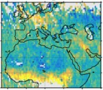
Sustainability data company Ecometrica called on countries and governments to adopt modern direct methods to measure climate-change emissions, following revelations by the BBC that official figures for emissions of climate-warming gases often are flawed, allowing some countries to underreport the level of pollution. “The time has come to move to direct monitoring of emissions and
Wednesday, November 2nd, 2016
Scientists produced the first global maps of human emissions of carbon dioxide ever made solely from satellite observations. The maps, based on data from NASA’s Orbiting Carbon Observatory-2 (OCO-2) satellite and generated with a new data-processing technique, agree well with inventories of known carbon dioxide emissions. No satellite before OCO-2 was capable of measuring carbon
Wednesday, September 28th, 2016
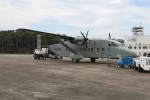
NASA is conducting low-level aircraft flights measuring greenhouse gases over the U.S. mid-Atlantic region for the CARbon Airborne Flux Experiment (CARAFE), which will measure the exchange of greenhouse gases such as carbon dioxide and methane between Earth and the atmosphere. Water vapor, temperature and vertical wind measurements also will be taken. “The direct measurements of
