
Monday, December 18th, 2017
Along with the larger forces of climate change, another contributing factor to the fierce wildfires in California has been the dry soil conditions. Light rainfall, combined with heavy use of aquifers by large farms, has created perfect conditions for an inferno. Stories of homeowners saving their homes by turning on sprinklers remotely are not as

Tuesday, December 5th, 2017
Esri will donate personal-use licenses of its ArcGIS software for each GISCorps volunteer who takes a GIS Service Pledge to volunteer for a good cause. GISCorps is a program of the Urban and Regional Information Systems Association (URISA) and has been providing a range of mapping and disaster response services for more than 14 years
Monday, November 27th, 2017
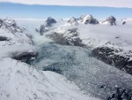
Monitoring ocean salinity is essential for understanding its impact on ocean circulation, Earth’s water cycle, marine ecology and climate change. Ocean salinity in the Arctic is of particular interest, because it changes significantly with seasonal ice cover and is expected to decrease as the Greenland ice sheet melts and releases massive amounts of freshwater. Despite

Monday, November 20th, 2017
Legislative sponsors Senator Orrin Hatch (R-UT) and Senator Mark Warner (D-VA), U.S. Representative Bruce Westerman (R-AR-04), and U.S. Representative Seth Moulton (D-MA-06) collaborated with GIS organizations across government and industry to advocate for common data standards, interagency collaboration and transparency to taxpayers on shared national data services. Agreeing to a common vision will make it

Monday, November 13th, 2017
Boeing completed the acquisition of Aurora Flight Sciences Corp., which will operate under Boeing Engineering, Test & Technology as a subsidiary called Aurora Flight Sciences, A Boeing Company. It will retain an independent operating model. Headquartered in Manassas, Va., Aurora has more than 550 employees and operates in six locations, including research and development centers
Monday, November 6th, 2017
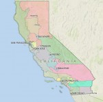
Members of the California Citizen’s Redistricting Commission went to Washington, D.C. in July 2017 to accept the Roy and Lila Ash Innovations Award for Public Engagement in Government for its California Redistricting Panel, which used Caliper’s Maptitude for Redistricting to draw its 2012 Congressional and State Legislative boundaries that have been recognized for effectively eliminating
Tuesday, July 25th, 2017
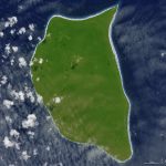
In the middle of the South Pacific Ocean, far from the urban, developed world, there’s a small, lush, green island with white sand beaches. However, this uninhabited, remote corner of the tropics—Henderson Island—also has a trash problem. The beaches of Henderson Island have the highest density of plastic waste in the world, according to a
