Tuesday, October 31st, 2017
The European Space Agency (ESA) and Radiant.Earth will jointly enhance geospatial data literacy in the global development community to help track the Sustainable Development Goals (SDGs). “Geospatial information is central to accurately tracking and measuring the global progress of the SDGs,” noted Radiant.Earth Founder and CEO Anne Hale Miglarese. The ESA and Radiant.Earth cooperation focuses
Tuesday, October 17th, 2017
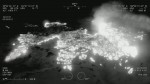
In support of CAL FIRE’s firefighting efforts in Northern California, the California Air National Guard’s 163d Attack Wing operating out of March Air Reserve Base is using MQ-9 Unmanned Aircraft Systems (UASs) with full-motion video (optical and infrared) and ground imaging Synthetic Aperture Radar (SAR) capability, which can see through clouds and smoke. “The 163d
Monday, October 9th, 2017
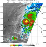
NASA’s Aqua satellite and NASA-NOAA’s Suomi NPP satellite analyzed the temperatures in Hurricane Nate’s cloud tops and determined that the most powerful thunderstorms and heaviest rain areas were around the center of the tropical cyclone after it made landfall near the mouth of the Mississippi River on Oct. 7, 2017. Infrared light provides valuable temperature
Monday, September 25th, 2017
Forest fires in Southeast Asia during the El Niño droughts of 2015 caused considerable disruption to the biodiversity of the region due to the smoke-induced haze they created, according to new research published in the Environmental Research Letters journal and led by Benjamin Lee at the University of Kent and the National Parks Board in
Monday, September 18th, 2017
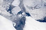
Operation IceBridge is flying in Greenland to measure how much ice has melted during the summer. The flights, which began on Aug. 25, 2017, and will go on until Sept. 21, 2017, repeat paths flown this spring and aim to monitor seasonal changes in the elevation of the ice sheet. “We started to mount these
Monday, September 11th, 2017
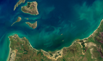
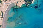
In early September 2017, ocean scientists noticed something swirling in the waters off the coast of the Brazilian state of São Paulo. The sinuous threads of darkness amid the blue Atlantic Ocean were not caused by oil; they were the result of a phytoplankton bloom. The dark colors are probably high concentrations of dinoflagellates, according
Tuesday, September 5th, 2017
The impacts of Hurricane Harvey are being felt far and wide. As the rain continued to fall, and flood waters rose, an army of citizen-rescuers answered the call. And as governments encouraged citizens to help one another, the non-profit organization made up of mapping experts also answered the call. GISCorps, a program of the Urban
Tuesday, August 22nd, 2017
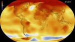
According to authors of a new study from the American Geophysical Union, it is “extremely unlikely” that 2014, 2015 and 2016 would have been the warmest consecutive years on record without the influence of human-caused climate change. Temperature records were first broken in 2014, when that year became the hottest year since global temperature records

Tuesday, August 15th, 2017
Sustainability data company Ecometrica called on countries and governments to adopt modern direct methods to measure climate-change emissions, following revelations by the BBC that official figures for emissions of climate-warming gases often are flawed, allowing some countries to underreport the level of pollution. “The time has come to move to direct monitoring of emissions and
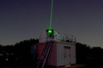
Tuesday, August 8th, 2017
NASA and the Norwegian Mapping Authority are partnering to develop a satellite laser-ranging station 650 miles from the North Pole that will produce high-precision locations of orbiting satellites, help track changes in ice sheets, and improve the efficiency of marine transportation and agriculture. The Arctic station will be the latest addition to a global network
