Thursday, October 13th, 2016
Proteus Geo, a leading provider of satellite-based mapping services and data, together with DHI, the world renowned consultant group within water environments, has won the backing of the European Space Agency (ESA) to create a new bathymetry data service that leverages DigitalGlobe satellite imagery to allow everyone to explore the shallows around the world’s coastlines.
Tuesday, October 11th, 2016
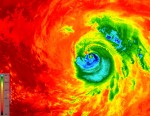
As Hurricane Matthew developed into a Category 4 hurricane that pummeled the Caribbean and southeastern United States, killing more than 1,000 people, disrupting electricity and other utilities to hundreds of thousands, and causing billions of dollars in economic damage, many of the world’s satellites and sensors were tuned to the storm, and recorded its path
Tuesday, August 30th, 2016
A 6.2 magnitude earthquake struck central Italy on Aug. 24, 2016. Approximately 300 people died as a result of the quake, which devastated several towns in the country’s Apennine mountain belt. The Italian peninsula features fault lines created by the separation of the African and Eurasian tectonic plates. The fault line separating these two plates
Wednesday, July 27th, 2016
Trying to measure sea levels around rugged coastlines is not always an easy task. ESA’s CryoSat satellite is making a difference with its radar altimeter. Sea level is a very sensitive indicator of climate change, reflecting components of the climate system such as heat, glaciers and the melting of ice-sheets. Precisely monitoring changes in the
Wednesday, July 13th, 2016
Getting the bigger picture on the health of our planet drew another step closer today as Europe’s Sentinel-3A satellite was handed over to Eumetsat for operations. Since it was launched in February, the satellite and its instruments have been meticulously fine-tuned to make sure that everything is fit and ready for the task in hand:
Tuesday, July 12th, 2016
12 July 2016 — In the most detailed picture to date, information from ESA’s CryoSat satellite reveals how melting ice in Greenland has recently contributed twice as much to sea-level rise as the prior two decades.Between 2011 and 2014, Greenland lost around one trillion tonnes of ice. This corresponds to a 0.75 mm contribution to
Friday, July 8th, 2016
ESA and China have launched the fourth phase of the collaborative Dragon programme in Wuhan City, on the Yangtze River, which recently experienced major floods witnessed by Europe’s Sentinel-1 satellite. ESA and representatives of China’s Ministry of Science and Technology (MOST) met in Wuhan to sign the cooperation agreement, which begins the fourth phase of
Friday, May 20th, 2016
The Sentinel-1A radar satellite has detected a potential oil slick in the eastern Mediterranean Sea – in the same area where EgyptAir flight MS804 disappeared early yesterday morning on its way from Paris to Cairo. The image was acquired by Sentinel-1A yesterday at 16:00 GMT (18:00 CEST). ESA has given information related to the image
Thursday, May 12th, 2016
12 May 2016 — While the growing volume information from satellites observing Earth offers a unique opportunity for science and applications, it is sometimes difficult to make sure these complex data streams are exploited to their full potential. ESA is addressing this challenge with ‘Thematic Exploitation Platforms’. The idea is to unlock satellite data and
