Wednesday, March 22nd, 2017
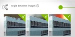
What are the effects of the “angle between images” setting in circular missions when it comes to 3D reconstruction? Knowing which drone flight plan to design for 3D modeling can be challenging, but the good news is that Pix4Dcapture has automatic flight missions optimized for different scenarios. We tested circular missions with three image angle
Thursday, September 8th, 2016
The National Geospatial-Intelligence Agency (NGA) and the National Science Foundation (NSF) released new 3-D topographic maps of Alaska on Sept. 1, 2016, in support of a White House Arctic initiative to inform better decision-making in the area. The 3-D digital elevation models (DEMs) are the first to come from the ArcticDEM project, which was created
Wednesday, June 29th, 2016
San Francisco, Calif. – SmarterBetterCities announces the latest release of CloudCities, the premier platform for hosting, sharing and visualizing your smart 3D city models. It fully supports Esri CityEngine, Google Earth, and SketchUp, enabling organizations worldwide to create efficiently and publish their 3D models across multiple platforms. CloudCities now supports ground-breaking real-time 3D streaming meaning
Tuesday, October 27th, 2015
Shepperton Studios, London, October 27, 2015 — RealVisuals is bringing historical artefacts to life with interactive 3D computer models created from laser scanner data generated using Pointfuse software. The Belgium based technology company has pioneered the use of Pointfuse for heritage applications, scanning and producing models of complex museum collections including pieces from the Flax Museum “Texture”
Tuesday, September 18th, 2012
3D models created from high resolution aerial photography are supporting the pioneering use of Building Information Modelling (BIM) on regeneration and construction projects across London. Created by Bluesky and supplied to David Miller Architects the 3D models accurately place the projects in their real world multi dimension context. This provides a base for the integration
