If Old McDonald had a farm today, he could manage it from his laptop computer and map it with an application on his handheld device. When he was out in the field, his tractor’s guidance system could know its position to within less than an inch, turning his planters and sprayers on and off accordingly. A boom height control system would make sure that his sprayer did not hit the ground and a yield monitor on his combine would measure the exact volume of his harvest, in real time. Soil moisture sensors networked via cellular modems, soil density sensors on his planters, and infrared crop health sensors on his tractor would gather a wealth of data that his agronomist would use to prepare a prescription map for the next season. In a few years, that data stream would also include aerial imagery collected by his unmanned aerial vehicle (UAV) and his tractor would also be running unmanned as a robot in the field. If a chick, duck, turkey, pig, cow, cat, mule, dog, turtle, or farm hand got in its way, the tractor’s radar collision avoidance system would recognize it and stop.
The most widely used term to describe this complex suite of technologies is precision agriculture, and the uptake is exploding. Most new tractors and implements are sold with factory-installed global navigation satellite system (GNSS) receivers and a variety of sensors. Reversing a long-standing trend, kids who were born and raised on farms are now returning there after college, because the work is much more intellectually challenging and less manual labor-intensive than it used to be.
Soil characteristics — including the amount of phosphorus, potassium, calcium, and magnesium — often vary significantly from one area of a field to another. The practice of variable rate takes this variability into account to reduce inputs of water, seed, fertilizers, and fuel as well as to increase yields by dividing fields into sectors and prescribing rates for each one.
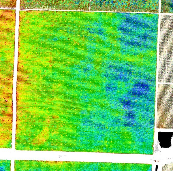
Figure 1: Field prescription map showing Normalized Difference Vegetation Index (NDVI) data at 30 centimeter resolution. Image courtesy of Simplot.
Fertilizer dealers, seed salesmen, and crop consultants analyze farm data and advise farmers on these rates. However, farmers can also create prescription maps themselves, by uploading soil type data, historical yield data, and aerial imagery into farm management software on their computers. They can then upload those maps to their tractors’ guidance systems, which use them to vary the rates depending on location, with wireless networks creating a farm-wide system.
Precision also plays with environmental impacts, such as reducing water use or the amount of farm chemicals in water.
“To be more efficient with our water and to stop flushing out so much nitrogen through the soil into the water table,” says Chris Gallo, a Precision Agriculture Specialist at Simplot, “many farmers are switching from flood irrigation to drip irrigation and micro-sprinklers.”
By managing their fields based on soil properties and putting fertilizer where it needs to go, farmers can better manage their nutrients. By setting up “exclusion zones” farmers are also able to automatically cut off the spray of fertilizer before it reaches a critical distance from a water supply. “That has saved many farmers from litigation and fines,” says Mike Martinez, a market manager at Trimble Agriculture.
Figure 2: A tractor towing a fertilizer sprayer using Trimble’s GreenSeeker system. Image courtesy of Trimble.
Another benefit of precision agriculture is that it enables farmers to avoid gaps and overlaps when planting. “We are also able to geospatially sense where we have already applied fertilizer and planted. That way the system cuts the supply at those points, so that you don’t waste inputs,” says Martinez.
Just as car buyers today expect Bluetooth integration and XM satellite Sirius radio, farmers expect new tractors to come with guidance. Case IH tractors, sprayers, and combines are sold with a factory-installed Glonass-enabled GNSS receiver, a display, and a controller, which consists of accelerometers and gyroscopes that compensate for uneven terrain.
“Just as you pay for different levels of XM radio in your vehicle, you pay to unlock different levels of positioning accuracy,” says Trevor Mecham, Americas marketing manager for Case IH, Advanced Farming Systems. “You can get free WAAS corrections or pay for DGPS accuracy that gets you plus or minus a couple of inches pass-to-pass.” he points out, referring to the Federal Aviation Administration’s Wide Area Augmentation System and the U.S. Coast Guard’s Differential Global Positioning System. “If you need year-after-year repeatability for controlled traffic farming, so that you can do the side dressing and strip till applications, you need RTK,” which stands for real-time kinematic satellite navigation.
Likewise, John Deere sells its tractors and combines with an integrated guidance system. “The sensors on the combines are already factory-installed for yield mapping and harvest documentation,” says Cole Murray, product manager for the company’s Intelligent Solutions Group (ISG). “We also have some add-on opportunities: for example, by adding a GPS receiver to a sprayer you can do swath control.”
John Deere owns NavCom, which designs and builds GNSS receivers and writes software. It also owns a differential corrections network, the StarFire network, which works worldwide.
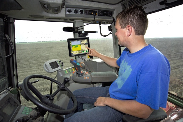
Figure 3: Farmer using a Trimble FmX integrated display. Image courtesy of Trimble.
Kinze manufactures planters and grain carts that quantify planting and harvesting. “We’ve added scales to these carts, so as farmers unload the grain from the combine into the cart, they can use it to record how much grain they are getting out in the field,” says Rhett Schildroth, one of the company’s product managers.
“When they are planting, farmers care about three things: how deep they plant that seed into the soil, getting good seed-to-soil contact, and the spacing between the seeds,” Schildroth explains. “So, we’ve added sensors in order to make sure that we can gauge each of those things and then also control it on the go, so that they can vary it throughout the field.”
Open fields would seem an ideal environment for satellite navigation, because they allow a clear view of the sky. This is usually true in the Midwest — say, in Kansas or Missouri — where there is just open space, rolling hills, and flat land. “However, there are just as many other areas around the world where some fields are totally surrounded by 100-foot trees with very dense canopies that do a very good job blocking satellite signals,” points out Martinez.
The technical challenges include multi-pathing, terrain difficulties, a reduced number of visible satellites at higher latitudes, and solar maxes. These are the same as those faced by surveyors but with the added challenge that farm systems are operating continuously. “If a surveyor has to wait 30 seconds to get a good signal, that’s not a big deal, but in 30 seconds in the field you have covered a lot of ground,” says Schildroth. Additionally, users of RTK may face the difficulty of radio communication between the base station and the rover over long distances and uneven terrain.
“To ensure that you have a connection at all times, you need either a portable system or a very strong signal from your base station,” Schildroth adds. “If you are using a cellular connection, for example on a CORS network, you need to make sure that you have cellular coverage throughout your field.” To address this issue, about a year ago Trimble released a service called CenterPoint RTX. “It is the industry’s first real-time, satellite-delivered correction service that is able to achieve inch to inch-and-a-half absolute accuracy, all delivered from satellite directly to the tractor,” says Martinez.
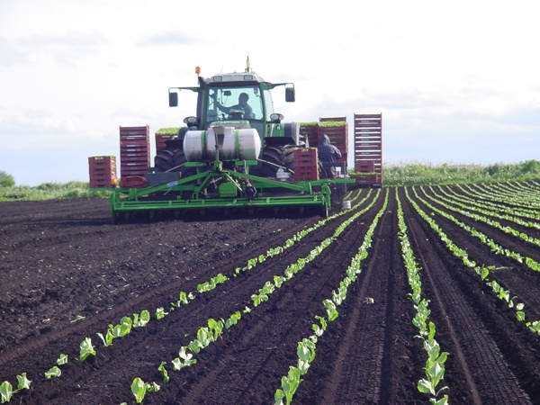
Figure 4: Planting lettuce with an automated planter in the United Kingdom. Image courtesy of Trimble.
Various services analyze farm data and generate prescription maps. Fertilizer dealers, crop consultants and agronomists take the data, analyze it, and help the farmers make decisions.
Nick Achen, an agricultural engineer, and his brother, a farmer, co-founded and co-own www.easyfarmmaps.com. “We identified a need in our community to be able to process all this data that farmers collect in the field,” he says. “There is software for sale that is expensive and complicated, so many farmers don’t know how to use it or don’t want to learn to use these systems. So we set up a Web site to take those files, process them into readable maps.”
AgJunction, a Web-based agronomy system operated by HemisphereGPS, allows users to import soil test data and the locations of the soil samples, as well as data from John Deere, Raven, Trimble and other systems, and generate prescription maps. Its customers are primarily agriculture retailers, such as independent chemical fertilizer retailers or cooperatives.
According to John Lueger, director of Product Management at Hemisphere GPS, “A retailer could use our system to send a prescription map directly to one of our terminals on a tractor or a sprayer and then the farmer, when he has completed that job, can send that data back to the retailer and automatically archive it for historical purposes.”
Other options and approaches from the different manufacturers take a similar approach. Raven Industries has a product called Slingshot that records what you are doing with various data sets and synchs to cloud-based software. Trimble’s Connected Farm wirelessly extracts the data from the growers’ applications throughout the seasons and consolidates it. Across the board, manufacturers assert that these technologies pay for themselves in about a season of use.
Figure 5: A Kinze Autonomous Harvest System, consisting of a tractor, a grain cart, and a combine. Image courtesy of Kinze.
Almost every piece of agricultural equipment has sensors and controls these days. Sprayers now have sensors that sense whether plants are nutrient deprived or not, and sensors dragged across the field show the textural variation in the soil.
“We use load cells on grain carts, magnetic flux sensors to sense when power take-off (PTO) shafts are turning and grain is unloaded, infrared sensors to count the seed as it goes down the seed tube, load cells on planters to understand the down force required to plant the seeds, and GPS receivers for positioning,” says Schildroth.
The use of soil moisture sensors, networked using cellular modems, is growing very rapidly. “When I was on our family farm, in the early 90s, the task I disliked the most was to go in the fields and read soil moisture content meters,” says Mecham. “Corporate family farms can have as many as 35,000 acres and one person doing just that all day. So, this is extremely important, especially in areas where you have to pump the water from deep well systems. Now farmers can receive that information via e-mail or text messages.”
“Our basic guidance system will come standard with a series of inertial sensors that provide feedback to the guidance system on the tilt of the field or the vehicle’s pitch, roll, yaw, or heading,” says Martinez. “Combines have optical sensors that record the volume that is passing through their grain elevator, as well as moisture sensors. So, in real time, we know the volume and we know the moisture content of that crop being harvested.”
Sensors are now being used to control the height of spray booms, which can be up to up to 120 feet across. “So, as they are traveling at high speeds across the field, if you don’t have a perfectly flat field, you are going to hit that boom on the ground,” Martinez points out. “It is no longer feasible for the driver to control the height of his boom fast enough. So, we just announced a system that uses ultrasonic sensors to sense, very quickly, the profile of the ground so that it can then, via hydraulics, move the boom up and down as needed.”
Trimble’s GreenSeeker sensor is a localized, real-time sensor that is mounted right to the spraying vehicle. It uses an optical sensor and a few different light bands to measure the health of the crop in real-time.
“Immediately, as the sprayer is traveling and recording this data, it is creating a prescription to also then apply nitrogen in the right amount needed in that particular portion of the field,” Martinez explains. The company’s WeedSeeker spot spray system uses advanced optics to sense whether a weed is present and signals a spray nozzle to deliver a precise amount of chemical—spraying only the weed and not the bare ground.
Future developments in precision agriculture include autonomous farm vehicles, the use of imagery from UAVs, and telemetry — wirelessly transmitting back to the office data on crop health, soil characteristics, and yield, as well as on the status of the farm machines, which will allow farmers to improve planning for vehicle servicing and maintenance, says Swain. Sensors that can analyze and manage soil compaction are also in the future, according to Achen.
Currently, growers get feature unlock codes from their dealer. “In the future,” says Mecham, “we would like dealers to be able to send them directly to the devices on the vehicles, via modem, to allow customers to try new features. Our customers are demanding that level of simplicity.”
This feature is one of a three-part series that appear in the publications of the Location Media Alliance, detailing various aspects of the application of geospatial technologies to food and agriculture. Read a detailed accounting of the crop lifecycle and supply chain in a feature titled, “Adding Track and Trace to the Agricultural Supply Chain,” that appears in LBx Journal. Read about how, “Mapping Local Resources Helps San Jose Battle Food Insecurity,” via Informed Infrastructure.