
Tuesday, January 15th, 2019
In the early 1990s, Acton Lake in southwestern Ohio had a muddy problem. Large amounts of sediment from nearby farms were entering the lake’s watershed. These sediments traveled through streams draining the landscape and were filling up the lake. So the USDA gave local farmers incentives to change some of their farming practices. One of
Tuesday, July 17th, 2018
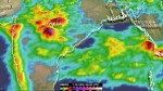
India’s southwest monsoon normally occurs between June and September and is known for being a summertime rainy season. This year’s monsoon has been assessed as average, but India’s Meteorological Department statistics show that daily mean rainfall for the country has recently been above normal. At least 15 people were killed by floods and landslides in
Monday, September 18th, 2017
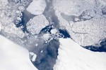
Operation IceBridge is flying in Greenland to measure how much ice has melted during the summer. The flights, which began on Aug. 25, 2017, and will go on until Sept. 21, 2017, repeat paths flown this spring and aim to monitor seasonal changes in the elevation of the ice sheet. “We started to mount these

Tuesday, September 5th, 2017
The impacts of Hurricane Harvey are being felt far and wide. As the rain continued to fall, and flood waters rose, an army of citizen-rescuers answered the call. And as governments encouraged citizens to help one another, the non-profit organization made up of mapping experts also answered the call. GISCorps, a program of the Urban
Wednesday, May 17th, 2017
Water conservation is a growing concern globally, and particularly for farmers in the United States, where decades of irrigating huge fields has depleted vital resources of fresh surface water and groundwater. To help alleviate this problem, a European Space Agency (ESA) spin-off that hopes to help preserve water supplies while guaranteeing crop irrigation is now

Tuesday, February 21st, 2017
The emerald golfing greens have seen better days. According to the U.S. National Golf Foundation, the number of players has steadily declined from over 30 million in 2005 (pre-recession) to 24.7 million today; 680 US and 158 Canadian courses have closed. “Golf course owners are working smarter to manage resources like water and labor more

Tuesday, January 24th, 2017
Hydrologists at the Colorado Basin River Forecast Center are providing streamflow forecasts for watersheds within the Colorado River Basin, which includes some of the most parched land in the United States. “The forecasts we get from the center provide crucial information for managing our water resources and reservoir facilities,” said Dave Kanzer, a deputy chief
Monday, November 14th, 2016
Researchers from UT Dallas and other universities developed geospatial science methods to help the Egyptian government determine how to avoid flooding in a coastal mountain region. The government wants to develop the area for tourism, but flash flooding and associated hazards have hampered efforts, according to Dr. May Yuan, Ashbel Smith professor of GIS. “We
Monday, October 24th, 2016
A new study using NASA satellite data finds that tide gauges—the longest and highest-quality records of historical ocean water levels—may have underestimated the amount of global average sea-level rise that occurred during the 20th century. A research team led by Philip Thompson, associate director of the University of Hawaii Sea Level Center in the School
Tuesday, March 25th, 2014
The U.S. Environmental Protection Agency (EPA) and U.S. Army Corps of Engineers (Army Corps) today jointly released a proposed rule to clarify protection under the Clean Water Act for streams and wetlands that form the foundation of the nation’s water resources. The proposed rule will benefit businesses by increasing efficiency in determining coverage of
