Wednesday, July 4th, 2018
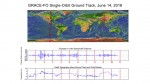
The laser ranging interferometer (LRI) instrument has been successfully switched on aboard the recently launched twin U.S./German Gravity Recovery and Climate Experiment Follow-On (GRACE-FO) satellites. The LRI, which is being flown as a technology demonstration, made its first measurements in parallel with GRACE-FO’s main microwave ranging instrument, and initial comparisons of the data from the
Tuesday, February 17th, 2015
Feb.17, 2015—To meet the great needs of high accuracy field data collection and better workflow via modern GNSS technology, Supergeo, the leading GIS software and solution provider, announces the latest SuperSurv (Android), the GIS mapping app, which not only allows users to connect with and operate external Bluetooth GNSS devices, but also elevates field work
Monday, March 10th, 2014
Optech, the world leader in the development, manufacture and support of high-accuracy lidar 3D survey systems and productivity-enhancing workflow software, is pleased to announce the release of the HydroFusion Turbid Water Module, a powerful new tool that enables the Optech CZMIL Coastal Zone Mapping and Imaging Lidar to collect bathymetry data in water conditions
Wednesday, March 5th, 2014
Leica Geosystems has announced the launch of its first wireless router for continuous monitoring, the Leica ComGate10. As integral part of Leica Geosystems’ mobile communication solution M-Com, ComGate10 is the first plug and play router on the market that offers users fast and fail-safe wireless data transfer, with the added benefit of a secondary back-up
Tuesday, February 25th, 2014
Supergeo Technologies, a leading global provider of complete GIS software and solutions, announced that SuperGIS 3D Earth Server 3.2 Beta is now released. The enterprise solution not only brings whole new map manipulation, but also assists professional users in managing, integrating, publishing, and displaying geographic data in 3D modeling environment.
Friday, February 21st, 2014
Blue Marble Geographics is pleased to announce the release of the Geographic Calculator 2014. This release features new functionality to display and support EPSG “Area of Use” Polygon data, improved Vertical Coordinate system handling, and a new Land Survey Summary job for generating printed layouts in Canadian survey systems. Blue Marble’s geospatial data manipulation, visualization
Friday, February 21st, 2014
Leica Geosystems Inc. and Airborne Hydrography AB today announced the availability of CHIROPTERA II, an innovative LiDAR solution for topographic mapping and shallow water surveying in depths of up to 15 meters (49 feet). The system simultaneously captures the full waveform in both the 35 kHz bathymetric channel and the 500 kHz topographic channel to
Tuesday, February 4th, 2014
Blue Marble Geographics (bluemarblegeo.com) is pleased to announce the release of the Global Mapper Software Development Kit (SDK) version 15.1. This minor release features read/write support for MS SQL Server Spatial databases, as well as added functionality for saving workspace files and an update to the area feature manipulation. Blue Marble’s geospatial data manipulation, visualization
Tuesday, February 4th, 2014
LizardTech, a provider of software solutions for managing and distributing geospatial content, announced the launch of Express Server 9 software. Express Server is the leading image-delivery software for compressed raster imagery, including multispectral imagery. It uses patented technology to reduce storage costs, decrease image loading times and handle thousands of image requests, all without sacrificing
Thursday, January 30th, 2014
Blue Marble Geographics is pleased to announce the release of Global Energy Mapper version 15.1. This minor release features a new option to the “Create Flattened Site Pad Plan” dialog box and improved processing of IHS Well (297/298) files. Blue Marble’s geospatial data manipulation, visualization, and conversion solutions are used worldwide by thousands of GIS
