Tuesday, July 10th, 2018
Representatives of 23 national organizations joined together to sign a letter in support of the 3D Elevation Program (3DEP) to newly confirmed USGS Director, Dr. James Reilly. Reilly was nominated by President Trump on Jan. 26, 2018, confirmed by the U.S. Senate on April 9, and took office as the 17th Director of USGS on

Tuesday, February 27th, 2018
Code for Africa, the continent’s largest federation of civic technology and data journalism labs, and Radiant.Earth, a non-profit advocating for open geospatial data for positive global impact, announced their partnership to harness open Earth imagery and tools for improved decision-making as well as better insight and transparency. Their combined efforts will focus on research for
Tuesday, December 12th, 2017
Esri and the United Nations Statistics Division (UNSD) are working with a number of member states to utilize a data hub that will allow countries to measure, monitor and report on the Sustainable Development Goals (SDGs) in a geographic context. This new hub, called the Federated System for the SDGs, is based on Esri’s ArcGIS
Monday, November 20th, 2017
Legislative sponsors Senator Orrin Hatch (R-UT) and Senator Mark Warner (D-VA), U.S. Representative Bruce Westerman (R-AR-04), and U.S. Representative Seth Moulton (D-MA-06) collaborated with GIS organizations across government and industry to advocate for common data standards, interagency collaboration and transparency to taxpayers on shared national data services. Agreeing to a common vision will make it
Monday, November 6th, 2017
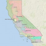
Members of the California Citizen’s Redistricting Commission went to Washington, D.C. in July 2017 to accept the Roy and Lila Ash Innovations Award for Public Engagement in Government for its California Redistricting Panel, which used Caliper’s Maptitude for Redistricting to draw its 2012 Congressional and State Legislative boundaries that have been recognized for effectively eliminating
Tuesday, October 31st, 2017
The European Space Agency (ESA) and Radiant.Earth will jointly enhance geospatial data literacy in the global development community to help track the Sustainable Development Goals (SDGs). “Geospatial information is central to accurately tracking and measuring the global progress of the SDGs,” noted Radiant.Earth Founder and CEO Anne Hale Miglarese. The ESA and Radiant.Earth cooperation focuses
Wednesday, June 20th, 2012
Today UN officials and country negotiators agreed on the final text of the Rio+20 declaration, entitled The Future We Want, which includes a call for the global phase-down of the factory-made super-greenhouse gases, hydrofluorocarbons (HFCs).
Wednesday, March 28th, 2012
The Honourable Joe Oliver, Minister of Natural Resources, today outlined the Government of Canada’s vision for the country’s future prosperity to government and industry leaders at a reception hosted by the Macdonald-Laurier Institute. The Minister emphasized that Canada is facing tremendous opportunity to capitalize on natural resource development and stimulate jobs and growth in a
Tuesday, March 27th, 2012
Geoinformation holds enormous potential: “Geoinformation plays an important role in all key sociopolitical issues,” said Prof. Karl-Friedrich Thöne at the INTERGEO Round Table in Karlsruhe. All participants were in agreement with the President of the German Society for Geodesy, Geoinformation and Land Management (DVW), the organization responsible for hosting INTERGEO from 9 to 11 October
Thursday, March 22nd, 2012
On Thursday, March 22, the Honorable Joe Oliver, Minister of Natural Resources, will address the Frontier Centre for Public Policy. A brief question-and-answer session will follow the speech. A photo opportunity and media availability will be held later in the day as the Minister tours the Rodren Drilling Ltd. Facility, a Manitoba-based exploration diamond drilling company
