Wednesday, July 26th, 2023
London – The Nippon Foundation-GEBCO Seabed 2030 Project has announced a new partnership with the Memorial University of Newfoundland’s Fisheries and Marine Institute – a leading centre of excellence for marine research and education. Seabed 2030 is a collaborative project between The Nippon Foundation and GEBCO to inspire the complete mapping of the world’s ocean
Tuesday, January 26th, 2021
GUANGZHOU, China – The UN warned last week that East Africa remains under the threat of desert locust invasions, due to the prevailing favourable breeding conditions which enable new swarms to form and increase. As African countries are getting prepared for the imminent locust crisis, the smart agtech company XAG has proposed that agricultural drones, through more targeted
Tuesday, April 21st, 2020
Washington, D.C. — With the 50th Anniversary of Earth Day (April 22) fast approaching, now more than ever we need to connect as a global community united in our fight to protect the health and welfare of the planet and its people. In support of this global movement, illustrious and preeminent religious leaders, environmental advocates, celebrities, musicians
Monday, March 23rd, 2020
St. Paul, Minnesota – This afternoon, Minnesota based nonprofit SharedGeo updated its online COVID-19 information map by adding two new features. In addition to the time lapse view of the virus spread across the United States by county since early March, now available is a national map and by state graphs showing progress toward “flattening
Tuesday, March 26th, 2019
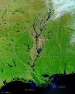
At least 200 gauges along the waterways of the Central United States—especially the Missouri and Mississippi river basins—reported some level of flooding on March 23, 2019. Thirty-six stations reported major flooding, and another 79 reported moderate floods. Historically high water levels could be a factor in the region for weeks, according to government forecasts. The
Tuesday, March 5th, 2019
Temperatures in the Arctic are rising twice as fast as in the rest of the world, causing permafrost soils to thaw. Permafrost peatlands are biogeochemical hot spots in the Arctic as they store vast amounts of carbon. Permafrost thaw could release part of these long-term immobile carbon stocks as the greenhouse gases carbon dioxide (CO2)

Tuesday, November 20th, 2018
Although most people might think smoke rises and then clears after a fire has been extinguished, the opposite is actually true. New research using data collected during NASA airborne science campaigns shows how smoke from wildfires worldwide could impact the atmosphere and climate much more than previously thought. The study, led by researchers at the

Tuesday, November 6th, 2018
The ozone hole that forms over the Antarctic each September is primarily driven by two factors: the amount of ozone-destroying chlorine in the polar stratosphere and the availability of ice crystals in stratospheric clouds for the chlorine to bind to. This year, the super-cold stratospheric temperatures measured by NOAA and NASA meant conditions were ripe
Tuesday, October 9th, 2018
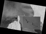
On Oct. 7, 2018, a Tunisian cargo ship is reported to have struck the hull of a Cypriot container ship in waters north of the French island of Corsica. There were no casualties, but the collision caused a fuel leak that resulted in an oil slick about 20 kilometers long. Although the collision occurred in
Tuesday, June 5th, 2018
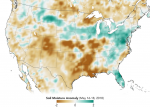
Data from the first NASA satellite mission dedicated to measuring the water content of soils is now being used operationally by the U.S. Department of Agriculture to monitor global croplands and make commodity forecasts. The Soil Moisture Active Passive (SMAP) mission launched in 2015 and has helped map the amount of water in soils worldwide.
