Tuesday, June 26th, 2018
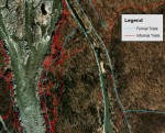
Most visitors to protected natural areas hike on trails created with hardened treads designed to sustain traffic. However, heavy hiking traffic and use by mountain bikers, motorized vehicles and horseback riders all take their toll. Parks also are becoming more crowded, with long lines of trail users during the popular summer season. More visitors have

Tuesday, March 27th, 2018
During the World Water Forum, Wetlands International launched a 10-year program in the second-largest wetland system in South America (after the Amazon): La Plata Basin. Corredor Azul will focus on mobilizing efforts to implement alternative development paths for the region by bringing together civil society organisations, the private sector, academia and governments. The program will
Tuesday, October 31st, 2017
The European Space Agency (ESA) and Radiant.Earth will jointly enhance geospatial data literacy in the global development community to help track the Sustainable Development Goals (SDGs). “Geospatial information is central to accurately tracking and measuring the global progress of the SDGs,” noted Radiant.Earth Founder and CEO Anne Hale Miglarese. The ESA and Radiant.Earth cooperation focuses
Monday, July 17th, 2017
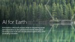
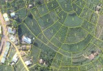
Land-cover mapping is a critical part of conservation planning, but current methods for collecting detailed geographic data are highly labor-intensive. Advanced technologies such as artificial intelligence (AI) can help, but they’re not yet widely accessible to those on the front lines of conservation and mapping. To improve this situation, Esri is collaborating with Microsoft to
Tuesday, June 27th, 2017
Satellites are helping to predict favorable conditions for desert locusts to swarm, which poses a threat to agricultural production and, subsequently, livelihoods and food security. Desert locusts are a type of grasshopper found primarily in the Sahara, across the Arabian Peninsula and into India. The insect is usually harmless, but when they swarm they can
Monday, February 6th, 2017
After Rwanda made waves in early 2016 for allegedly being the first country to approve drone delivery, people payed attention. The country, with its rolling hills and one of the fastest-growing economies in Central Africa, now has established regulations regarding drones and has become a vanguard of sorts for the region. “My impression is that
Thursday, September 22nd, 2016
SCOTLAND/ UNITED KINGDOM – Academics and students at the University of Edinburgh School of Geosciences are set to become the first to gain unlimited access to millions of pounds worth of state-of-the-art Earth Observation, geospatial intelligence and satellite mapping applications, thanks to a groundbreaking memorandum of understanding (MoU) signed between sustainability software and data company
Thursday, March 6th, 2014
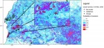
The EEA report, ‘Spatial analysis of green infrastructure in Europe‘, maps a network of natural and semi-natural spaces and other environmental features in Europe with a good capacity to deliver ‘ecosystem services’. These include air filtration, erosion protection, regulating water flow, coastal protection, pollination, maintaining soil structure, water purification, and carbon storage. The report also
Thursday, January 16th, 2014
Trees do not slow in their growth rate as they get older and larger — instead, their growth keeps accelerating, according to a study published today in the journal Nature.
Thursday, November 14th, 2013
A new study based on Earth-observing satellite data comprehensively describes changes in the world’s forests from the beginning of this century. Published in Science today, this unparalleled survey of global forests tracked forest loss and gain at the spatial granularity of an area covered by a baseball diamond (30-meter resolution).
