Friday, June 5th, 2026
Maptitude earns the highest composite score in the GIS category and 6 Top Feature awards in the 2026 Data Quadrant Report NEWTON, MA (USA) – Global research and advisory firm Info-Tech Research Group has named Maptitude the 2026 Data Quadrant Champion for Geographic Information Systems (GIS). Maptitude received the top recognition in the report with a composite score of 8.4 out
Thursday, June 4th, 2026
London, 4 June 2026 – The Association for Geographic Information, the membership group for organisations and individuals working in the geospatial sector, is delighted to announce its 2026 annual award winners. Presented at the GEO Business event in London yesterday, the awards celebrate excellence in the sector, recognising innovation, achievement, and best practice. “We have once
Thursday, June 4th, 2026
Leading geospatial and mapping event selects industry leaders to help deliver critical insights to geospatial professionals Salt Lake City, Utah, USA, June 4, 2026 – Organizers of Geo Week, the premier conference and tradeshow that brings together geospatial and mapping professionals, have announced an impressive list of influential leaders who will be participating on the
Thursday, June 4th, 2026
Developed in partnership with WGIC and its 50+ member organizations, Clark University and the University of Southern California will each offer the Executive Doctor of Geospatial Leadership (DGEO) program starting Summer 2027. London, June 2: The World Geospatial Industry Council (WGIC) is pleased to announce its support for the launch of the world’s first
Thursday, June 4th, 2026
WESTMINSTER, Colo., June 4, 2026 — Trimble today announced an integration with The Work Number® from Equifax® to provide automated income and employment verifications relying on payroll data, through its Trimble® Spectrum and Trimble VistaTM financial management software. Trimble Vista and Trimble Spectrum® software users can now add efficiency to a historically manual process with
Wednesday, June 3rd, 2026
NV5, a US-based provider of compliance, technology, and engineering consulting solutions, has added the Leica TerrainMapper-3 to its airborne fleet following an extensive real-world evaluation programme across complex landscapes. Proven performance for all terrain Survey teams mapping steep mountainous landscapes, corridors, or dense urban infrastructure face significant challenges, often having to choose between flying multiple
Wednesday, June 3rd, 2026
Upgraded edge computing platform delivers ultra-high-resolution video acquisition, onboard AI processing, and real-time streaming for space applications. Rehovot, Israel – Maris-Tech Ltd. (Nasdaq: MTEK, MTEKW) (“Maris-Tech” or the “Company”), a global leader in artificial intelligence (“AI”)-based edge video processing technology, today announced it is increasing its efforts in the space sector with the development of
Tuesday, June 2nd, 2026
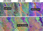
A new suite of geospatial innovations designed to turn data into actionable intelligence for global food systems was announced on May 27, 2026. The Geospatial Innovation for Food Security (GIFS) Challenge selected three project awardees to develop tools that will aid humanitarian agencies, governments and agricultural specialists to navigate the complexities of agricultural production, climate
Tuesday, June 2nd, 2026
AI-powered reality capture bridges the gap between remote 3D visualization and timely, collaborative progress-to-plan tracking Trimble announced that Trimble ProjectSight® 360 Capture is now available for customers across North America, the United Kingdom and Ireland. The new AI-powered reality capture capability within the comprehensive Trimble ProjectSight project management software application gives construction teams a more
Tuesday, June 2nd, 2026
2 June 2026: Creality unveiled Pika, a next-generation AI-powered portable 3D scanner co-developed with Orbbec, during its 12th Anniversary “AI Ecosystem” product launch event. Powered by Orbbec’s core underlying technologies, Pika breaks the mold of traditional 3D scanners by combining high-precision scanning, intelligent AI computing, and an ultra-portable design into one compact device. This launch marks a significant leap
