
Friday, March 30th, 2018
As advances in technology make it more cost-effective to deploy IIoT, industries will need to acquire a strategic approach to integrating new sensor data with pre-existing data environments. Now, more than ever, industries are seeking simple integrations with controls, automation and data analytics visualization software to harness the power of the Industrial Internet of Things
Sunday, October 1st, 2017
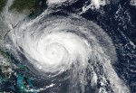
By Dr. Ahmed Abukhater As Hurricane Harvey made landfall on the Texas Gulf Coast on Aug. 25, 2017, with winds topping 130 miles per hour, the situation signaled a disaster on the horizon. The winds and heavy rains caused significant flooding, toppled branches and power lines, and lead to massive blackouts across the region. With
Monday, April 17th, 2017
Successful drone entrepreneur Petr Lněnička went from award-winning filmmaker to drone inspection leader in his native Czech Republic. Here he lays out 3 pieces of advice and explains why for him, the transition seemed logical, and why he believes the future of drone mapping services will place less and less emphasis on drones and more
Thursday, March 30th, 2017
Headquartered in Beaumont, California, Bogh Engineering is a 3rd generation family owned construction and engineering company with 65 employees. It focuses on construction of public schools, and is currently working on 14 job sites including building the 1.4 million square foot Indio High School. “90% of our business is focused on schools because we understand

Wednesday, March 22nd, 2017
What are the effects of the “angle between images” setting in circular missions when it comes to 3D reconstruction? Knowing which drone flight plan to design for 3D modeling can be challenging, but the good news is that Pix4Dcapture has automatic flight missions optimized for different scenarios. We tested circular missions with three image angle
Wednesday, December 21st, 2016
In recent years, the news media portrayed unmanned aircraft systems (UASs), commonly known as “drones,” as the technology of choice to take aerial images (photos and/or videos) of everything under the sun, from sporting events to weddings, surveys, real estate, construction monitoring, and so on. Unless operated indoors, UASs fly in the National Air Space

Tuesday, July 1st, 2014
One of the more impressive earth observation achievements in recent years was the collaboration between Google and the University of Maryland to create a global forest change assessment and visualization. This effort was unprecedented in terms of the raw computing power applied to the substantial Landsat archive, and yielding results that opened a lot of

Tuesday, June 10th, 2014
Google Earth is all about putting things in geographic context, aiding literacy and helping users in discovery. This capacity that started out with Keyhole technology has continuously evolved to include more data, and greater usability now with direct interface integration with Google Maps. From its early origins, the tool has also been applied to local

Tuesday, May 27th, 2014
The United Nations Environment Program is responsible for assisting countries in the collection of environmental data for more informed development, improving their quality of life without compromising that of future generations. Jacqueline McGlade, formerly the executive director of the European Environment Agency for ten years, recently joined this group as Chief Scientist, bringing her passion

Monday, December 16th, 2013
A recent opinion piece by Kirk Goldsberry, visiting scholar at Harvard University, gained a good deal of attention because it advocated for a return of a geography department to that august institution. Sensors & Systems (S&S) special correspondent Matteo Luccio spoke with Goldsberry about his background, about the need to reveal spatial patterns, and
