Thursday, August 22nd, 2013
Cutting edge optical sensor technology is being used in the Mississippi River basin to more accurately track the nitrate pulse from small streams, large tributaries and ultimately to the Gulf of Mexico.
Tuesday, August 6th, 2013
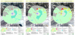
Scientists have sorted out and mapped the aquifers in the Little Spokane River Basin, giving the first detailed picture of the groundwater system, according to a report published by the U.S. Geological Survey, in cooperation with Spokane County.
Monday, August 5th, 2013
Key factors have been identified that help determine the vulnerability of public-supply wells to contamination. A new USGS report describes these factors, providing insight into which contaminants in an aquifer might reach a well and when, how and at what concentration they might arrive. About one-third of the U.S. population gets their drinking water from
Tuesday, July 30th, 2013
The Santa Cruz River watershed, located on the Arizona-Sonora portion of the U.S.-Mexico border, depends for its perennial flow on an international treatment plant that treats wastewater on both sides of the border before discharging it into the river in Arizona. This treated wastewater has great value for nearby wildlife and ecosystem managers, property owners
Wednesday, July 24th, 2013
The U.S. Geological Survey’s Wyoming and Montana water science centers will merge in October, improving science capacity and capabilities by integrating scientists in the two centers and allowing them to share equipment and expertise.
Tuesday, July 23rd, 2013
The use of satellite data to monitor wetlands for sustainable water management is growing. Following promising results from monitoring efforts in the Mediterranean, ESA is working with African partners to expand its GlobWetland project even further.
Thursday, July 18th, 2013
Have you ever dropped a stick into a river and wondered where it might go if it floated all the way downstream? Now you can trace its journey using Streamer – a new on-line service from the National Atlas of the United States. Streamer is an online map service that lets anyone trace downstream along
Tuesday, July 16th, 2013
A new USGS groundwater model provides a tool for evaluating possible solutions to the saltwater encroachment in the “2,000-foot” sand aquifer of the Baton Rouge area, an important source of groundwater for Baton Rouge. The just-released computer model simulates groundwater flow in the two primary sections of Baton Rouge’s aquifer, the “1,500-foot” and “2,000-foot” sands.
Thursday, July 11th, 2013
A new USGS report describes how the health of our Nation’s streams is being degraded by streamflow modifications and elevated levels of nutrients and pesticides.
Thursday, June 20th, 2013
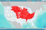
In 2012, the continental United States suffered through one of its worst droughts in decades. Nearly 80 percent of the nation’s farm, orchard, and grazing land was affected in some way, and 28 percent experienced extreme to exceptional drought. As another summer arrives in North America, surface water conditions have improved in many places, but drought has persisted or
