Tuesday, July 30th, 2013
Esri released the new version of ArcGIS today, marking a major milestone in the history of the Esri platform. With ArcGIS 10.2, Esri has taken advantage of the significant changes in IT that magnify the power and accessibility of GIS. The new release improves ease of use, real-time data access, and integration with existing infrastructure.
Wednesday, June 26th, 2013
PCI Geomatics, a world leading developer of remote sensing and photogrammetric software and systems, announced today the release of Geomatica Discover, PCI’s new browser-based software tool that crawls local, system drives or removable drives to automatically create a searchable geospatial data catalog.
Tuesday, June 18th, 2013
Trimble introduced TerraFlex today, a new software and services platform to manage data collection activities for everyday geospatial projects. Trimble TerraFlex helps managers maintain control of the flow of geo-enabled field data.
Tuesday, June 18th, 2013
PCI Geomatics, a world leading developer of remote sensing and photogrammetric software and systems, announces it has released Geomatica 2013 Service Pack 2 (SP2) for both Windows and Linux operating systems.
Tuesday, June 18th, 2013
Supergeo announced that SuperGIS Server 3.1a Advanced Edition will be released in Q3 2013, to support multiple extension analysts and advanced geoprocessing services.
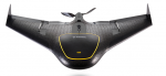
Monday, June 17th, 2013
Trimble (NASDAQ: TRMB) introduced today its next generation Unmanned Aircraft System (UAS)—the Trimble® UX5 aerial imaging rover with the Trimble Access™ aerial imaging application. The new solution builds upon the strengths of its predecessor, the Trimble Gatewing X100, to offer enhanced image quality and intuitive workflows. Combined with the Trimble Business Center photogrammetry office software
Monday, June 10th, 2013
Safe Software, makers of FME, the leading spatial data transformation technology, today announced the availability of FME 2013 Service Pack 2 (SP2) that includes the latest fixes and updates for FME Desktop and FME Server, plus some exciting new functionality. These added capabilities, as always, enable users to access more data in new ways, but
Thursday, June 6th, 2013
Leica Geosystems, the world’s leading manufacturer of airborne mapping solutions, announced today Leica FlightPro, a new state-of-the-art flight management and sensor control system that makes survey flights more effective and effortless for Leica Geosystems and Z/I Imaging as well as third party airborne sensors. It not only reduces stress on the flight crew by highly
Thursday, June 6th, 2013
Leica Geosystems, the leading manufacturer of airborne mapping solutions, announces major enhancements to its superior line sensor workflow Leica XPro. The new version v5.3 of the XPro data processing software produces even better results by delivering a higher level of automation and more accuracy.

Thursday, May 30th, 2013
Leica Geosystems, a leading manufacturer of airborne mapping solutions, announces today that it has entered into a cooperation and distribution agreement with Aibotix, an innovative manufacturer of multicopter unmanned aerial systems (UAS) to create end-to-end solutions for the professional inspection and mapping market.
