Tuesday, December 5th, 2017
Esri will donate personal-use licenses of its ArcGIS software for each GISCorps volunteer who takes a GIS Service Pledge to volunteer for a good cause. GISCorps is a program of the Urban and Regional Information Systems Association (URISA) and has been providing a range of mapping and disaster response services for more than 14 years
Tuesday, October 3rd, 2017
The Directorate of Resource Surveys & Remote Sensing (DRSRS) under the Ministry of Mining in Kenya is using SimActive’s Correlator3D for extensive mapping of mining activities. The software generates orthomosaics, contour lines and digital terrain models of fluorspar mines in the Kerio valley in Kenya. “The DRSRS provides the Ministry of Mining with spatial information,
Tuesday, August 8th, 2017
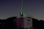
NASA and the Norwegian Mapping Authority are partnering to develop a satellite laser-ranging station 650 miles from the North Pole that will produce high-precision locations of orbiting satellites, help track changes in ice sheets, and improve the efficiency of marine transportation and agriculture. The Arctic station will be the latest addition to a global network
Tuesday, August 2nd, 2016
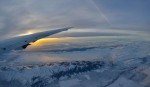
NASA scientists and engineers are field testing the CO2 Sounder LiDAR, an instrument powerful and accurate enough to gather around-the-clock global atmospheric carbon-dioxide (CO2) measurements from space. The instrument is a strong contender for a potential next-generation carbon-monitoring mission, the Active Sensing of CO2 Emissions over Nights, Days and Seasons (ASCENDS). The LiDAR operates by
Wednesday, March 28th, 2012
Events that reward educational initiatives pertaining to non-profit and profit specialism reflect experiences that have allowed us to gain a broad perspective on the implementation of new curricula, including ‘disadvantaged’ sectors, but not limited to, and falling within the field of geomatics and intelligent geography. These events have been analyzed in a number of European countries (eg Italy, England and
Wednesday, March 14th, 2012
The city of Bullhead City received two responses to its RFQ (Request for Qualifications) regarding the development of Section 12, in the vicinity of Community Park. The city leases 276 acres from the federal Bureau of Land Management, 67 of which front the Colorado River. The remainder of the land is on the east side
Friday, March 2nd, 2012
This abstract describes a systematic procedure for analysing corrugated asbestos-cement roofing sheets with Remote sensing test, Open Source data and other analysis (e.g. chemical and medical test) in order to analyse the asbestos fiber air dispersion that can cause lung cancer. To develop this procedure, we should implement test field and laboratory measurements and gathered airborne hyperspectral
Monday, February 27th, 2012
A catapult, a 3-D virtual reality system for use in training doctors, and a microscope that can magnify an almost invisible object to 200,000 times its size, were among the equipment on public display this afternoon inside the UAB School of Engineering. Equipment was displayed in a carnival like atmosphere, with balloons, popcorn, and games, in rooms
Friday, February 17th, 2012
Offshore wind cost reduction, natural gas and energy efficiency are some of the solutions that the EU could use in order to achieve its ambitious targets and boost its competitiveness in the energy arena, writes Anders Eldrup, chief executive of Dong Energy. Anders Eldrup is the chief executive officer of DONG Energy of Denmark. The following
Wednesday, February 1st, 2012
Reading this story by candlelight? Then odds are you live north of Eglinton Ave. Toronto Hydro has mapped out the areas of the city most prone to blackouts. They are concentrated in North York, northern Scarborough, and the former City of York, where some neighbourhoods suffer a dozen blackouts a year or more, on average. Read More
