Friday, April 19th, 2024
COLUMBIA, Md.-RouteSmart Technologies, a leader in route planning and optimization solutions, has released a new suite of tools designed to enhance waste management services for clients who collect garbage and recycling in alleyways. This innovative feature in RouteSmart Online addresses the unique challenges waste haulers face when servicing alleys in urban environments. Unlike streets, alleys
Friday, April 19th, 2024
MISSOULA, Mont.- American drone maker Skyfish will unveil Osprey — at Xponential Booth #4350 — a new survey-grade, enterprise drone that fits in a backpack. Purpose built for infrastructure inspection and ISR, Osprey supports best-in-class, compact third-party sensors such as the new Sony LR1 61-megapixel camera for inspection and photogrammetry and NextVision’s Raptor for ISR. The
Friday, April 19th, 2024
NASHVILLE, Tenn. and RESTON, Va.- Arcadus, a technology leader in the digital twin/3D spatial data market serving the Public Sector, and Carahsoft Technology Corp., The Trusted Government IT Solutions Provider®, today announced a strategic partnership. Under the agreement, Carahsoft will serve as Arcadus’ Master Government Aggregator®, making Arcadus’ digital twin solutions available to the Public Sector
Friday, April 19th, 2024
Fort Lauderdale, FL- Drone Nerds, a leading consumer and enterprise drone solutions provider, has officially announced a strategic partnership with the newest drone manufacturer to join the industry, Anzu Robotics. Recently emerged in the drone industry, Anzu Robotics has officially launched its American-owned drone solutions into the market. Headquartered in Austin, Texas, Anzu Robotics brings
Friday, April 19th, 2024
GEO Business, the UK’s largest geospatial event, returns to ExCeL London on 5-6 June 2024. GEO Business is a platform for you to connect with the geospatial community and unlock the potential of geospatial innovation. This free-to-attend expo acts as a one-stop-shop for finding the latest solutions to collect, analyse, store and share spatial data.
Friday, April 19th, 2024
Rome– e-GEOS, a Telespazio (80%) / Italian Space Agency (20%) company, has been awarded by the European Union Satellite Centre (SatCen) for the renewal of the supply of geospatial products for the Copernicus Security Service component on Support to EU External and Security Actions (SESA). Acting as Prime Contractor, e-GEOS will lead an European industrial
Friday, April 19th, 2024
Faster Overall Workflow AARSCHOT, Belgium – Virtual Surveyor has enhanced its popular smart drone surveying software with new planimetric survey capabilities. In addition to multiple performance modifications, Virtual Surveyor version 9.5 now enables users to quickly, easily, and accurately survey 2D features from drone orthophotos and add them to the 3D topographic model generated from the
Tuesday, April 16th, 2024
FAA-Designated Test Site and Leaders to Join Presentations at AUVSI XPONENTIAL GRAND FORKS, North Dakota – Known for results and innovation, the Northern Plains UAS Test Site marks its 10th anniversary this year. The Federal Aviation Administration-designated test site provides a crucial collaboration with the FAA and the unmanned aircraft system (UAS) industry, developing
Monday, April 15th, 2024
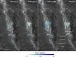
California’s Death Valley, the driest place in North America, has hosted an ephemeral lake since late 2023. A NASA-led analysis recently calculated water depths in the temporary lake over several weeks in February and March 2024, demonstrating the capabilities of the U.S.-French Surface Water and Ocean Topography (SWOT) satellite, which launched in December 2022. The analysis found
Monday, April 15th, 2024
Euroconsult and SpaceTec Partners are merging to create a new company, Novaspace. The two companies that have a combined 60 years of experience in covering the space sector will aim to create a strong combined company in the areas of market intelligence, consulting, events. The two companies announced the merger, April 5. Novaspace has 10 offices around the world
