Tuesday, June 1st, 2021
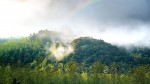
The rate at which plants and the land surface release moisture into the air has increased on a global scale between 2003 and 2019. These processes are collectively known as evapotranspiration, and a new NASA study has calculated its increase by using observations from gravity satellites. By gauging the mass change of water between the
Friday, May 14th, 2021
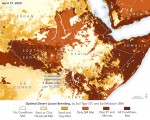
In 2019-2020, eastern Africa experienced its worst desert locust invasion in more than 40 years. The United Nations and its partners treated more than 17,000 square kilometers (6,600 square miles) of locust infestations across 10 countries with various eradication methods. Countless crops were still devoured by the insects, causing serious food insecurity in the region.
Tuesday, May 4th, 2021
In a decade filled by record-breaking events, including raging wildfires, numerous hurricanes, unseasonal flooding and historically cold temperatures, NASA has continued to learn more about how the planet is changing and the effect it has on Earth’s systems. In the satellite era, a fleet of Earth-observing satellites have gathered data on worldwide rain and snowfall,
Tuesday, April 20th, 2021
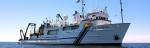
After a year in lockdown due to COVID-19, the Environmental Protection Agency’s largest research vessel Lake Guardian has set sail. Eleven scientists supported by a 15-member crew will live and work aboard the ship in April 2021. The work on the Lake Guardian is EPA science at its best. Among other activities, these scientific sailors
Monday, April 5th, 2021
One of the largest Adélie penguin colonies in the world was surveyed with multiple-UAVs. Survey time was reduced from three days (with a single drone manually piloted) to less than three hours. The work was led by a team of experts from Stanford University, Point Blue Conservation Science and Conservation Metrics. UgCS software by SPH
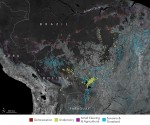
Tuesday, March 23rd, 2021
Some 20 year ago, in response to severe water shortages, the South African government passed the National Water Act, which is intended to restrict the amount of water farmers use for irrigation. However, ensuring farmers only take the water to which they’re entitled is tricky. Maurits Voogt, who works for HydroLogic, a relatively small company
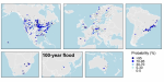
Tuesday, March 9th, 2021
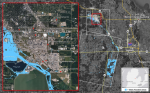
Severe river floods are escalating in temperate climates and putting at risk populations, livelihoods and property, according to evidence published in Geophysical Research Letters by an Oxford-led international team. The first global examination of recent changes in the size, frequency and probability of extreme river floods using historical river records, the paper shows that dangers
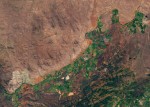
Monday, February 22nd, 2021
After intense fires in the Amazon captured global attention in 2019, fires again raged throughout the region in 2020. According to an analysis of satellite data from NASA’s Amazon dashboard, the 2020 fire season was actually more severe by some key measures. The Visible Infrared Imaging Radiometer Suite (VIIRS) sensors on the Suomi NPP and
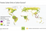
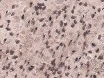
Tuesday, February 9th, 2021
Using ground, airborne and satellite data, a diverse team of international researchers—including NASA scientists—created a new method to assess how the changes in forests during the last two decades impacted carbon concentrations in the atmosphere. In addition to better understanding the overall role of forests in the global carbon cycle, the scientists were also able
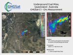
Tuesday, January 26th, 2021
An optical sensor that can map methane emissions from space at a resolution 100 times higher than any other sensors was deployed on Jan. 20, 2021, with the successful launch of satellite Hugo from GHGSat. The new greater granularity will allow the identification of the source of emissions, rather than just the general area. The
