Tuesday, March 19th, 2019
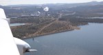
A 15-year study by researchers in South Australia and Germany mapped the source, journey and effect of ultrafine particles in the lower troposphere. It found that filtration systems on modern coal-fired power stations are the biggest individual source of ultrafine particles (UFPs), ahead of urban road traffic. Results were gathered using ultralight research trikes and
Tuesday, March 12th, 2019
A classic scenario plays out in action films: criminals evade aerial pursuit from the authorities by seamlessly blending in with other vehicles and their surroundings. The Air Force Office of Scientific Research (AFOSR) now has Rochester Institute of Technology (RIT) researchers utilizing hyperspectral video imaging systems that make sure it doesn’t happen in real life.
Tuesday, March 5th, 2019
Temperatures in the Arctic are rising twice as fast as in the rest of the world, causing permafrost soils to thaw. Permafrost peatlands are biogeochemical hot spots in the Arctic as they store vast amounts of carbon. Permafrost thaw could release part of these long-term immobile carbon stocks as the greenhouse gases carbon dioxide (CO2)
Monday, February 25th, 2019
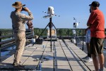
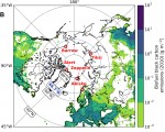
Fossil fuel combustion is the main contributor to black carbon collected at five sites around the Arctic, which has implications for global warming, according to a study by an international group of scientists. The five-year study to uncover sources of black carbon was done at five remote sites around the Arctic and is published in
Thursday, February 14th, 2019
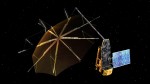
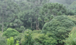
Set to fly in 2022, ESA’s Biomass Earth Explorer satellite with its 12-meter diameter radar antenna will pierce through woodland canopies to perform a global survey of Earth’s forests—and see how they change over the course of Biomass’ five-year mission. Trees are an integral, much-loved element of our environment; they also hold clues to our
Tuesday, February 12th, 2019
The Amazon rainforest isn’t necessarily a place that many would associate with a drought, yet prolonged dry spells are projected to become more prevalent and severe because of climate change. The question at hand is how these droughts are going to affect the rainforest, as it has a large influence on global climate and future
Tuesday, February 5th, 2019
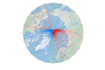
Earth’s northern magnetic pole is moving quickly away from the Canadian Arctic toward Siberia. This movement has forced National Centers for Environmental Information (NCEI) scientists to update the World Magnetic Model (WMM) mid-cycle. Typically, a new and updated version of the WMM is released every five years. With the last release in 2015, the next
Tuesday, January 29th, 2019
The Sustainable Ocean Alliance (SOA), a global nonprofit organization that advances the impact of young ocean leaders, released its first State of Our Ocean Annual Report, an annual assessment of the health of our ocean based on the analysis of SOA young leaders and ocean experts. In launching this report at the start of 2019,
Tuesday, January 22nd, 2019
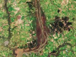
The Copernicus Sentinel-2B satellite collected this image of the lower reaches of the brown, sediment-rich Uruguay River where the river forms the border between Argentina and Uruguay, and is the site of the Esteros de Farrapos e Islas del Río Uruguay wetlands. Composed of lagoons, swamps and 24 islets, the Esteros are a haven for

Tuesday, January 15th, 2019
In the early 1990s, Acton Lake in southwestern Ohio had a muddy problem. Large amounts of sediment from nearby farms were entering the lake’s watershed. These sediments traveled through streams draining the landscape and were filling up the lake. So the USDA gave local farmers incentives to change some of their farming practices. One of
