Tuesday, August 6th, 2019
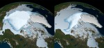
Losing the remaining Arctic sea ice and its ability to reflect incoming solar energy back to space would be equivalent to adding one trillion tons of CO2 to the atmosphere, on top of the 2.4 trillion tons emitted since the Industrial Age, according to current and former researchers from Scripps Institution of Oceanography at the
Tuesday, July 30th, 2019
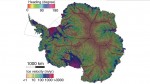
Far more accurate than any previous map, this new representation of glacier flows in Antarctica opens the door to an improved understanding of the vast continent and the future pace of sea-level rise. To create the new map, researchers at the University of California, Irvine, and NASA’s Jet Propulsion Laboratory in Pasadena, Calif., combined input

Tuesday, July 23rd, 2019
Louisiana is officially sinking. It has been 29 years since the National Geodetic Survey (NGS) measured the state’s subsidence. After completing four absolute gravity observations this past year, with the help of LSU’s Center for GeoInformatics (C4G), the NGS’s most-recent findings show the state’s change in elevation. “This is the second observation NGS has performed

Tuesday, July 16th, 2019
During summer 2019, 28 undergraduate students are participating in an eight-week NASA airborne science field experience that will immerse them in the agency’s Earth Science research. NASA’s Student Airborne Research Program (SARP), embarking on its 11th year, offers an opportunity for undergraduates majoring in sciences, mathematics and engineering to participate in all aspects of a
Tuesday, July 9th, 2019
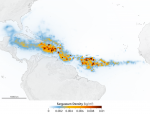
An unprecedented belt of brown algae stretches from West Africa to the Gulf of Mexico—and it’s likely here to stay. Scientists at the University of South Florida in St. Petersburg’s College of Marine Science used NASA satellite observations to discover and document the largest bloom of macroalgae in the world, dubbed the Great Atlantic Sargassum
Tuesday, July 2nd, 2019
Snowflakes that cover mountains or linger under tree canopies are a vital freshwater resource for over a billion people around the world. To help determine how much freshwater is stored in snow, a team of NASA-funded researchers is creating a computer-based tool that simulates the best way to detect snow and measure its water content
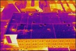
Tuesday, June 25th, 2019
By John Anderson, Strategic Business Development, FLIR Systems Inc. A new tool is making roof inspections safer, faster, and more efficient by reducing the need for dangerous treks up and across rooftops. Many roof inspectors are now investing in unmanned aerial vehicles (UAVs)—commonly known as drones—equipped with thermal and visible cameras so they can more
Tuesday, June 18th, 2019
Using rare oxygen molecules trapped in air bubbles in old ice and snow, U.S. and French scientists have answered a long-standing question: How much have “bad” ozone levels increased since the start of the Industrial Revolution? “We’ve been able to track how much ozone there was in the ancient atmosphere,” said Rice University geochemist Laurence

Tuesday, June 11th, 2019
By Jami Harmon, GSSI Antennas used with ground penetrating radar (GPR) come in different shapes and sizes. The largest antennas typically radiate the lower frequencies necessary to detect the deepest targets. The smallest antennas radiate the highest frequencies that provide the greatest resolution required to detect small, shallow targets. The “best” antenna for a job
Tuesday, June 4th, 2019
On the heels of the first definitive signs of the ozone layer recovery in 2018, an international team of scientists discovered that production and emission of a banned, potent ozone-depleting chemical is on the rise again. A new research finding, published in Nature on May 23, locates the source region for about half of those
