Tuesday, October 15th, 2019
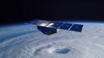
Eight briefcase-size satellites flying in a row may be key to improving forecasts of a hurricane’s wind speed—detecting whether it will make landfall as a Category 1 or a Category 5. NASA’s Cyclone Global Navigation Satellite System (CYGNSS) fleet, launched in 2016, was designed to show whether the same GPS signals your phone uses for
Tuesday, October 8th, 2019
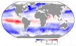
As we pump more greenhouse gases into the atmosphere, the world is warming at an alarming rate, with devastating consequences. While our vast oceans are helping to take the heat out of climate change, new research shows that they are absorbing a lot more atmospheric carbon dioxide than previously thought—but these positives may be outweighed
Tuesday, October 1st, 2019
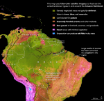
The Amazon basin is exceptional. It spans at least 6 million square kilometers (2.3 million square miles), nearly twice the size of India. It is home to Earth’s largest rainforest as well as the largest river for the volume of the flow and the size of the drainage basin. The rainforest, which covers about 80
Tuesday, September 24th, 2019
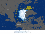
Arctic sea ice reached its annual summer minimum on Sept. 18, 2019, according to NASA and the National Snow and Ice Data Center (NSIDC). Analysis of satellite data by NSIDC and NASA showed that the extent of ice cover this year effectively tied 2007 and 2016 as the second lowest in the satellite record, which
Tuesday, September 17th, 2019
Hot and dry. These are the watchwords for large fires. While every fire needs a spark to ignite and fuel to burn, it’s the hot and dry conditions in the atmosphere that determine the likelihood of a fire starting, its intensity and the speed at which it spreads. Over the past several decades, as the
Tuesday, September 10th, 2019
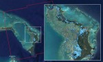
The Advanced Rapid Imaging and Analysis (ARIA) team at NASA’s Jet Propulsion Laboratory in Pasadena, Calif., in collaboration with the Earth Observatory of Singapore (EOS), used synthetic aperture radar data from the European Union’s Copernicus Sentinel-1 satellites to produce this flood map of the Bahamas. The light-blue color indicates areas that were likely flooded when
Tuesday, September 3rd, 2019
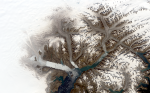
Ice fronts have retreated, rocky peaks are more exposed, fewer icebergs drift to the ocean: the branching network of glaciers that empty into Greenland’s Sermilik Fjord has changed significantly in the last half century. Comparing Landsat images from 1972 and 2019, those changes and more come into view. The glaciers appear brownish grey in this
Tuesday, August 27th, 2019
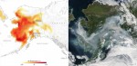
Thousands of fires have broken out in the Amazon rainforest. Satellite data show that there are almost four times as many fires this year compared to the same period last year. Apart from Brazil, parts of Peru, Bolivia, Paraguay and Argentina have also been affected. While forest fires normally occur in Brazil’s dry season, which
Tuesday, August 20th, 2019
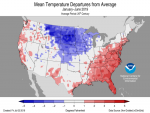
A new “State of the Climate” report released on Aug. 12, 2019, by the American Meteorological Society (AMS) confirms that 2018 was one of the hottest years on record. Global surface temperatures continued the trend in which every year since the turn of the 21st century has been hotter than any year experienced in the
Thursday, August 8th, 2019
NASA selected a space-based instrument under its Earth Venture Instrument (EVI) portfolio that will make observations of coastal waters to help protect ecosystem sustainability, improve resource management and enhance economic activity. The selected Geosynchronous Littoral Imaging and Monitoring Radiometer (GLIMR) instrument, led by principal investigator Joseph Salisbury at the University of New Hampshire, Durham, will
