Tuesday, December 20th, 2011
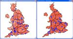
Senior politicians do not always appreciate the value of Geographic Information and Location Intelligence. With their minds now sharply focused on boundary changes for the UK Parliament, nothing brings home the importance of spatial analysis as clearly as the threat of losing some seats. In this article Jamie Justham, Chairman of Dotted Eyes, one of the UK’s

Monday, November 21st, 2011
Founded in 1985, ECTP-CEU (European Council of Spatial Planners-Conseil européen des urbanistes) brings together 25 professional town planning associations and institutes from 23 European countries as well as corresponding members. It is an umbrella association providing its members with a common framework for planning practice, planning education, continuing professional development and the definition of professional

Friday, November 18th, 2011
I recently had the good fortune to attend a GeoDesign workshop presented by Bill Miller, who is the Director of GeoDesign Services at Esri, and one of the people credited with coining the term. It was a fascinating morning, and it was a reflection of how important this topic is becoming that Alex Miller, president

Monday, November 14th, 2011
Supply chains include both upstream and downstream relationships involving goods, services and customers. The delivery of geographic information (GIS) will necessarily include each of these. The Supply-Chain Operation Reference (SCOR) Model can be used to interpret and understand geospatial supply chains. The mapping of the various processes will assist a GIS unit to understand the processes involved

Monday, October 31st, 2011
The annual Esri European User Conference was held in Madrid, Spain October 26-28, 2011. With 3000 registered for this event, it made it one of the largest that the company has held in Europe. While most of the audience was from Spain, followed by other Europeans, there were many people attending from distant locations around

Friday, October 21st, 2011
Spatial Data Infrastructures in Context – North and South discusses both technological and non-technological obstacles, policies and mechanisms with respect to the implementation of spatial data infrastructures (SDI). With an emphasis on non-technology issues such including legal, policy, copyright, liability and compatibility factors, the editors provide a wealth of information aimed at improving access, interoperability and

Wednesday, October 19th, 2011
The LAS format – introduced in 2004 by the ASPRS – has become the de-facto international standard for storing and exchanging point data acquired by airborne LIDAR scanners. It has wide acceptance and can be read and written by almost any LIDAR processing software. There now exist Exabytes of LIDAR that can easily be exchanged

Saturday, October 15th, 2011
Mapumental is a start up of mySociety, the organisation that builds award-winning non-profit websites and carries out commercial work for clients such the BBC, The Guardian, Google, and national and local government. In 2007 the project started develop prototypes for real time maps that could handle huge amounts of travel data. In 2009 it won

Thursday, October 13th, 2011
This book presents information about climate adaptation and flood risk scenarios for coastal cities. Jakarta, Rotterdam and New York are selected for investigation. The book considers areas that are not adjacent to coastal areas that contribute to flood risk impacts such as drought and temperature changes. The authors wonder if new infrastructure can be designed

Sunday, October 2nd, 2011
The 17th Annual INTERGEO was held this past week in the historic city of Nuremberg, Germany. This event brought together 16,000 people from 80 countries, and delivered 140 presentations on a variety of topics to a conference audience in addition to presenting one of the largest trade show in the world, including the latest products and
