
Tuesday, May 10th, 2022
By Joseph Shih, Seal-Connect Technical Product Specialist, Greene Tweed The use of distributed sensing (DS) is on the rise, especially for sensitive oil and gas and pipeline applications, structural health monitoring in concrete structures, and subsea cable infrastructure monitoring for offshore wind energy power sources. DS enables precise monitoring that can benefit operators seeking to
Tuesday, June 25th, 2019
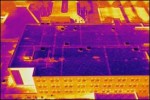
By John Anderson, Strategic Business Development, FLIR Systems Inc. A new tool is making roof inspections safer, faster, and more efficient by reducing the need for dangerous treks up and across rooftops. Many roof inspectors are now investing in unmanned aerial vehicles (UAVs)—commonly known as drones—equipped with thermal and visible cameras so they can more

Tuesday, June 11th, 2019
By Jami Harmon, GSSI Antennas used with ground penetrating radar (GPR) come in different shapes and sizes. The largest antennas typically radiate the lower frequencies necessary to detect the deepest targets. The smallest antennas radiate the highest frequencies that provide the greatest resolution required to detect small, shallow targets. The “best” antenna for a job

Friday, March 30th, 2018
As advances in technology make it more cost-effective to deploy IIoT, industries will need to acquire a strategic approach to integrating new sensor data with pre-existing data environments. Now, more than ever, industries are seeking simple integrations with controls, automation and data analytics visualization software to harness the power of the Industrial Internet of Things

Tuesday, January 30th, 2018
Sensors withstand extreme temperatures, pressures and aggressive chemicals By Will Meenan, Kaman Precision Products/Measuring It takes an extremely durable design to make reliable measurements in extreme conditions. Extreme environment position/displacement sensors perform where most sensors cannot survive. These sensors are designed to operate in the following environmental conditions: · High or cryogenic temperatures · Aggressive

Tuesday, December 5th, 2017
Esri will donate personal-use licenses of its ArcGIS software for each GISCorps volunteer who takes a GIS Service Pledge to volunteer for a good cause. GISCorps is a program of the Urban and Regional Information Systems Association (URISA) and has been providing a range of mapping and disaster response services for more than 14 years
Sunday, October 1st, 2017
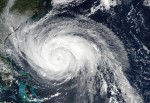
By Dr. Ahmed Abukhater As Hurricane Harvey made landfall on the Texas Gulf Coast on Aug. 25, 2017, with winds topping 130 miles per hour, the situation signaled a disaster on the horizon. The winds and heavy rains caused significant flooding, toppled branches and power lines, and lead to massive blackouts across the region. With

Monday, August 28th, 2017
By Mike Gundling Ever since the first GPS satellite went aloft–and especially since the first smartphones and tablets provided GPS positioning–government, industry and academia have been in a never-ending search for new ways to use location-based data. Environmental organizations conduct wetland delineation surveys. Transportation companies track trucks and trains. Public-service officials seek law-enforcement and emergency
Monday, April 17th, 2017
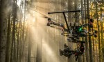
Successful drone entrepreneur Petr Lněnička went from award-winning filmmaker to drone inspection leader in his native Czech Republic. Here he lays out 3 pieces of advice and explains why for him, the transition seemed logical, and why he believes the future of drone mapping services will place less and less emphasis on drones and more
Thursday, March 30th, 2017
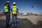
Headquartered in Beaumont, California, Bogh Engineering is a 3rd generation family owned construction and engineering company with 65 employees. It focuses on construction of public schools, and is currently working on 14 job sites including building the 1.4 million square foot Indio High School. “90% of our business is focused on schools because we understand
